Unlike the previous blog entries, this isn't going to be about cycling. I'm visiting South America for the first time, arriving at the end of September 2015 and I'm going to visit 7 countries - Brazil, Uruguay, Argentina, Paraguay, Bolivia, Peru and Chile - in about 6 weeks. It's a packed itinerary involving a lot of flights and long bus journeys so it's not going to be practicable to bring a bike with me. I do however have my skates with me so at least some of the journey will be on wheels, thereby justifying an entry in the Everywhere On Wheels blog. And I certainly hope to do at least some cycling, if the opportunity arises.
Tuesday 29th September 2015
I left London Heathrow at noon on a BA flight to Rio which proceeded uneventfully, and comfortably enough. On arrival at around 8.30pm local time, it didn't take long to clear customs and it was quite easy to find the limousine bus to the city. However it took an hour and a half to get to my hotel in Copacabana, owing to slow moving traffic all the way, so it was about 11pm when I arrived.
Wednesday 30th September
It was rather cloudy all day, and very warm and humid.
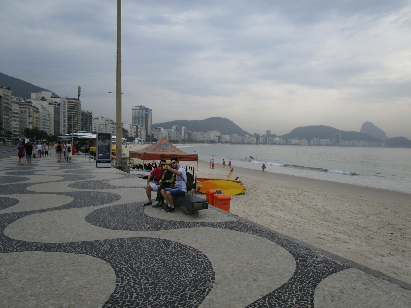
I started off exploring the city, with a good skate along Copacabana and Ipanema beaches, where there was a decent bike path:

Heading west around the coast for a short distance after Leblon I came to a favela, a shanty town perched on a cliff face:

Leblon beach - with the Christ the Redeemer statue visible in the distance

A short distance inland from Ipanema is the Lagoa (Lagoon) - which has a smooth bike path around its 7km perimeter. I did a couple of circuits around this, enjoying a great view of the Corcovado mountain with the Christ statue:


I then skated towards the centre, along some very rough pavements and cycle paths, then took a ride up the Corcovado summit in the cog-driven train, which winds up to a height of 670m in the course of a 25 minute steep climb through dense jungle:


The statue is highly impressive owing to its vast size:

Despite fairly poor visibility the views from the top were still spectacular:


There was quite a long wait for the train back down. I considered walking but it looked as though rain was about to start.
I then took another bus back into the centre and nearly had my phone stolen by someone who tried to snatch it through the open bus window while the bus was stationary. Fortunately I was holding it tightly so they weren't successful. You certainly have to be very careful with your valuables here!
I had a bit of a walk around the centre but by now it was too dark to see much. Took a metro back to Copacabana, noticing that some carriages were women only:

... and had dinner at Cervantes restaurant. I chose a rump steak which was excellent quality, but ridiculously large, easily big enough for 2 people:

Thursday 1st October
I took a bus a few kilometres east towards Leme, where I took the cable car up to the summit of Sugar Loaf mountain. The journey is in two stages and there are great views to be had, however it was somewhat cloudy at first.

By the time I reached the second summit, visibility had improved. Leme beach is in the foreground, Copacabana is on the left, and on the right is the view towards the city centre.

This view shows the city centre, with Santos Dumont airport at the right of the picture:

You can just make out the Christ the Redeemer statue in the centre distance:

View of Sugar Loaf from the descending cablecar:


I took a bus into the centre, alighting at the Memorial to the dead of World War 2, a striking modernist structure designed by Brazil's most famous architect, Oscar Niemeyer:

I then enjoyed an excellent lunch in the Confeitaria Colombo, a beautiful old cafe which is a Rio institution:

From here it was easy to walk around the centre and take in the most significant buildings:

Teatro Municipal

Candelaria church

Palacio Tiradentes, the Rio state parliament

Palacio Duque de Caxias, a military headquarters building

New Cathedral and Bell Tower

Praca da Republica, where independence from Portugal was proclaimed in 1822 - this large park is full of agoutis:

After getting the subway back to the hotel, I walked the 3kms along the beach to Ipanema and had dinner at Garota de Ipanema, originally a bar named Veloso, where the song Girl from Ipanema was written in 1962. It's now firmly on the tourist map and very busy. The food wasn't bad, but I was disappointed that there was no samba music being played. Afterwards I walked back to the hotel along the beach again and felt perfectly safe, despite many warnings against walking around the area after dark.

Friday 2nd October
I took a bus to Santos Dumont airport which is right in the centre of town, in time for an 11 am flight to Brasilia with GOL airlines, flying time 1 hr 45 mins and a distance of about 1000 kms.
Constructed in just 4 years commencing in 1956, Brasilia became the country's capital city in 1960. Many of the main buildings were designed by Oscar Niemeyer in the Modernist style, and they are already looking somewhat past their best. Much of the concrete is cracking up and bits seem to have fallen off roofs and walls, and some of the buildings have had to undergo extensive renovation, while others, particularly the Aztec Pyramid style National Theatre, remain neglected and scruffy.
The city was planned entirely around the motor car and is laid out on a massive scale. Most of the hotels are in a sector quite close to the centre so it was possible to walk around most of the sights. I had a very luxurious suite in the Melia Hotel shown here:

After lunch at the hotel I went for a skate down the Eixo Monumental, the main axis street, taking in the main sights on the way to Lake Paranoa, which lay around 4kms beyond the city, along a series of well-paved cycle paths.

Cyclepath down the Eixo Monumental, with the Cathedral and Art Gallery in the background

JK bridge over Lake Paranoa
Lake Paranoa is a massive artificial lake built to increase water availability and humidity. There wasn't a lot to see there, however, apart from the graceful arches of the JK bridge, named after Juscelino Kubitchek, the Brazilian president who ordered the construction of Brasilia.
For dinner I took a walk over to Carpe Diem, one of the most renowned restaurants in Brasilia, highly recommended by the Rough Guide. Like every meal I've had so far in Brazil, the portion sizes were way too big but the food was good.
The hotel had free bikes for hire which, unlike many hotel hire bikes, were actually quite good quality and well-manitained, so I took one for a ride over to the nearby Park Cidade. This is said to be the largest urban park in the world, and while it wouldn't win any awards for landscaping, it does have a big amusement park which appeared to be very popular, and more importantly, a series of smooth tarmac cycle and walking paths, the longest being a 10km circuit. There were lots of skaters there:

I then rode 2kms north to the Juscelino Kubitchek memorial, containing a museum about the life of Brasilia's founder, as well as a mausoleum containing his black marble sarcophagus. Some of the information was in English, fortunately, so it was an interesting exhibit. To gain entry the steps go down through an artificial lake surrounding the building:

A statue of JK sits on top of a weird question mark structure, which points towards the heart of the city:

Across from the JK memorial, the Museum of Indigenous Peoples had a good exhibit about the Zoe Amerindian tribe, with whom first contact was made very recently, with many excellent photographs.
Next stop was the TV tower which had a free observation platform which gave excellent views of the city, from here the vast scale of the layout could be appreciated:


I returned the bike, got my skates and went back to the park for a couple of circuits around the 10km track.
Had a really nice evening meal at a restaurant called Coco Bambu; Salmon ceviche, a good Brazilian red wine, and two excellent mojitos, which were even better than the ones I had in Cuba earlier this year.
Sunday 4th October
Walked down the Eixo Monumental taking in all the main buildings and monuments. First stop was the dome-shaped Museu Nacional, which had a good exhibition of modern art:

Adjacent is the Cathedral and Bell Tower:

The Palacio Itamarati, the foreign ministry building, is one of the more attractive buildings, combining modernist and classical styles:

The Praca dos Tres Podores (Plaza of the Three Powers) represents the Congress, judiiciary, and presidency. The two large bowls, one inverted, house the Senate and the House of Representatives:

Opposite is the Planalto Palace which houses the president's office:

This strange building is the Panteao da Patria, dedicated to 10 Brazilian national heroes:

Also nearby is the Supreme Court building, with a statue of blind Justice in the forecourt:

The National Theatre is built in the form of an Aztec temple, however it's currently closed and in a somewhat neglected state:

Monday 5th October
Next stop was Sao Paulo - South America's biggest city and the 6th most populous on Earth. The flight took about one and a half hours. The airport is quite a long way from the centre so the bus there took about an hour. I stayed in the Hotel Itamarati, an old building very close to Praca Republica:

It was a rather overcast day and much cooler than the last few days in Brasilia. I took a walk around the centre and immediately got the feeling that it's not the safest of places to wander around. The streets are absolutely full of homeless people, and their smell pervades pretty much everywhere. I've never seen anywhere with so many police, they are everywhere, on foot, in cars, on motorbikes, yet the place still feels really unsafe. There are dodgy looking characters everywhere. This city is the economic powerhouse of Brazil and doubtless there is a lot of prosperity here but the differential between rich and poor is massive.
There are many fine buildings and monuments but a lot are covered in the worst kind of graffitti, just meaningless scrawl without any artistic merit.

Teatro Municipal, a striking mix of Art Nouveau and Renaissance styles:

Banespa building, modeled on New York's Empire State building:

Se square and the Metropolitan Cathedral:

Tuesday 6th October
The weather was much warmer, and sunny all day. I visited the Mercado Municipal, a huge food market where I tried the local dish called pasteis de bacalhau - a tasty salt fish and potato pie:


This is the main railway station, built by the British in 1901:


This picture shows one of the many perfectly good buildings in everyday use which have been hideously defaced with graffitti:

Sao Paulo's first skyscraper, the Edificio Martinelli (built 1929) isn't as impressive as the Banespa building but it does allow visitors up to the roof, from where some good views can be had:

This French-style mansion, the Casa des Rosas, now a museum, is one of the last surviving old buildings along the Avenida Paulista, a main artery now lined with skyscrapers.

Wednesday 7th October
By now I'd seen enough of the centre of Sao Paulo, and it was time to escape out to somewhere more scenic. An half-hour's journey north on the subway followed by another half hour on a bus took me to the Cantareira State Park, a large urban native forest with a number of walking trails. When I arrived however I found it was closed to visitors on weekdays, however I managed to plead with one of the park rangers and he kindly let me in. I took a 6km return walk up to Pedra Grande, a large rock from where excellent views over the city can be obtained:


The trail was tarmac all the way, which detracted somewhat from the forest setting. There are lots of monkeys living in the forest and I could hear them chatting loudly but sadly wasn't able to see any. Still it was a very pleasant walk and a welcome relief from the pollution and squalour of downtown Sao Paulo.
Afterwards I got the subway back to the centre and continued south to Ibirapuera Park, a very large and well laid out urban park which was a nice place to walk around, it has a number of museums and galleries, and a scenic lake:


Behind the oramental fountains, the obelisk in the background is a memorial to those who died in the 1932 uprising against one of the country's military dictatorships.
After a day spent doing quite a lot of walking I had worked up a good appetite and had an excellent meal at Famiglia Mancini, one of Sao Paulo's most renowned Italian restaurants. I then got an early night's sleep, as I had to be up at 3am the next day to catch an early flight.
Thursday 8th October
The flight to Montevideo, Uruguay, the next stop on my itinerary, departed at the rather uncivilised time of 5.25 am, and it was the most turbulent flight I have experienced for a long time, bumping around for most of the two-and-a-half hour journey.
From Montevideo airport it was about an hour's bus ride into the centre of town, and it was a short walk to my hotel, the Palacio - which was in a beautiful old colonial building. My room, on the top floor, had a balcony with views on both sides over the River Plate estuary:


The hotel was right next to the Ciudad Vieja (old city) - the original town founded in 1726, and laid out in a grid pattern of narrow streets. I was advised not to walk around the old city after dark, but it certainly is a pleasant enough place during the daytime.
The main focal point of Ciudad Vieja is Constitution Square, Uruguay's oldest square, dominated by the Cathedral:


Further towards the harbour is Zabala Square, named after the founder of Montevideo, and which has a large statue of him:

By the harbour, the Mercado del Puerto is a beautiful old market building containing a number of restaurants with large open grills where seafood and meat are cooked while you watch. I had an excellent kingclip (a local fish) with some great local wine, in this beautifully atmospheric setting.

Back towards the hotel is the Puerta de la Ciudadela, which leads onto Independence Square, which commemorates the emergence of Uruguay as a sovereign nation. In the centre is a statue of Jose Artigas who started the campaign for independence from Spain and Portugal:


Also on Independence Square is the bulbous Palacio Salvo, built on the site of the first ever performance of tango:

Nearby is the Teatro Solis, Uruguay's most prestigious theatre building:

Montevideo is full of museums, and I managed to visit one before closing time - an exhibition relating to the Andes plane crash of 1972, in which 16 passengers (out of 45) survived an ordeal of over 70 days in sub zero conditions, having had to resort to eating the remains of those who had died in the crash and its aftermath. It was very interesting and well presented.
My lunch at the Mercado del Puerto was so big that I really didn't feel like eating in the evening, so just got an early night's sleep to make up for the very early start I had had that morning.
Friday 9th October
The weather was overcast, but pleasantly warm. I took a walk around the rest of the city, heading east towards the large Parque J Batlle y Ordonez, which contains the football stadium which was the scene of the first ever World Cup, back in 1930:

The tree-lined streets have many well-preserved and elegant old buildings:

The Motor Museum, on the top floor of a multi-storey car park, had a good number of historic vehicles on display:

Saturday 10th October
I took the 10 am bus to Colonia del Sacramento, a picturesque and historic little town, originally a 17th century Portuguese smuggling port, and from where I would get the ferry across the River Plate to Buenos Aires, my next destination, later that day. I had about 3 hours to explore Colonia, which was plenty of time.
The lighthouse, built in 1857:

View from the lighthouse:

Calle de los Suspiros - probably Uruguay's most photographed street:

Iglesia Matriz - the oldest church in Uruguay:

City wall fortifications:

The Buquebus ferry departed at 4.15 and the journey to Buenos Aires took about an hour.

From the dock at Buenos Aires it was about a 20 minute walk to the Hotel Alcazar where I was staying, which is in the centre of town on the Avenida Mayo. On the way there I saw a very large carnival parade and stopped to watch for a while. Unfortunately it was so overcast that it wasn't possible to get any decent photos of this colourful spectacle:


Sunday 11th October
Some research on Facebook had revealed that there was to be a street skate at 11am starting in the north of the city, and I was looking forward to meeting some of the local skaters. On the subway ride there, however, I checked the event webpage using the free wifi available on the Buenos Aires metro, and found that it had been cancelled, owing to rain forecast for later that day.
I decided to go on to the start place and see if any skaters were there, but there weren't any so I went for a good long skate by myself, taking in the extensive parklands that stretched back towards the centre - which had a decent network of bike paths. There were lots of skaters especially around the large lake, and even a few slalomers:

With rain impending I skated back into the centre along the bike path following the Av del Liberator:

It wasn't a great day for taking good photos, but I did stop at the obelisk on Av. 9 July to try and capture the scale of this huge avenue, said to be the widest in the world:

By now the rain had started, only a light shower but the tiled pavements were far too slippery to skate. I was close to the hotel so left the skates there and walked further down the Av de Mayo towards the Casa Rosada (Pink house) at the end of Plaza de Mayo, scene of many turbulent events in Argentina's history, including bombing by its own military during various coups d'etat.
There's a memorial to Argentine soldiers who died in the Falklands War, although this isn't the official one - which will be visited later:

The Casa Rosada, home to the Presidential offices, is the large pink building in the background of this photo:

I joined the queue to get in for a guided tour:

It was worth seeing inside, especially for several displays showing the Falkland Islands as Argentine territory:

This was the only room where photography was allowed:

Next stop nearby was the Bicentenial museum which was about Argentina's political history, it had some good exhibits but all the information was in Spanish unfortunately:

From there it was a short distance to Puerto Madero, an old disused dock area which has been redeveloped with many new restaurants and art galleries. This pedestrian bridge across the dock is said to have been inspired by the shape of a couple tango dancing:

Dinner was at this popular parrilla (grill) restaurant in San Telmo, a historic area just south of the city centre, which has narrow cobbled streets:

Monday 12th October
It was much warmer than yesterday, a pleasant spring day, ideal for strolling around and taking in the sights. Buenos Aires is certainly an attractive, well laid out city, full of attractive buildings and monuments, and plenty of green spaces. It's quite clean, with relatively few homeless people compared to the other cities I've visited on this trip.
Everywhere you go there are people asking if you want to change money at unofficial rates - which are apparently 50% higher than the official rate. I wish I had taken some US dollars with me as they are evidently in huge demand, it seems that Argentinians have very little faith in their own currency, hardly surprising given their history of numerous defaults and hyperinflationary episodes.
From the hotel I walked north towards the Retiro district, an upmarket residential area, where I found the official Falklands War memorial:

Somewhat ironically, just across the street from the memorial is this ornate tower built by English residents of Buenos Aires a century ago, and which was originally called the English Tower:

Next stop was the 18th century Basilica de Nuestra Senora de Pilar, a beautifully restored old Jesuit building with a magnificent Baroque silver altarpiece. Next door is Recoleta cemetery, the resting place of many Argentine celebrities, including the embalmed remains of Eva Peron, buried under her maiden name of Duarte, in this typically ornate mausoleum:


Following the military coup shortly after her death, her body was removed to a secret grave in Italy where it lay for 16 years before being returned to Argentina.
All the graves in the cemetery are highly elaborate and large:

Heading back towards the centre I passed by the Teatro Colon, the principal theatre of Argentina:

The 67 metre obelisk on Av 9th July was built in 1936, and is the place where football fans gather to celebrate their team wins:

Also on Av 9th July is this curious "mini Iguazu Falls" display. I'm going to the real thing after Buenos Aires, so didn't bother to risk getting soaked by approaching too close to this version:

The evening's entertainment was a Tango show at the Luis Borges cultural centre, not far from my hotel. It was really enjoyable, amazing dancing and excellent music and singing too. Following this I had a very late evening meal, starting at around 11pm - that's quite early by Argentinian standards.
Tuesday 13th October
Another fine warm day, which I again spent walking around various sights. I had breakfast at the famous Cafe Tortoni, just a few doors from my hotel, a Buenos Aires institution where Luis Borges and other Argentine cultural luminaries used to hang out. There was a queue to get in and the service was very slow:

Here's another view of Av 9th July, looking west. The white building with the antenna on top is the Ministry of Health, and it has a large image of Eva Peron addressing the crowds:

In search of more culture, as ever, I whiled away an interesting hour or so in the Eva Peron museum, in this building which was formerly one of many social welfare centres that Peron herself set up:

It's clear that she and her husband are still held in very high regard here, judging by the many visitors that the museum attracts. It had a good restaurant, where I had lunch.
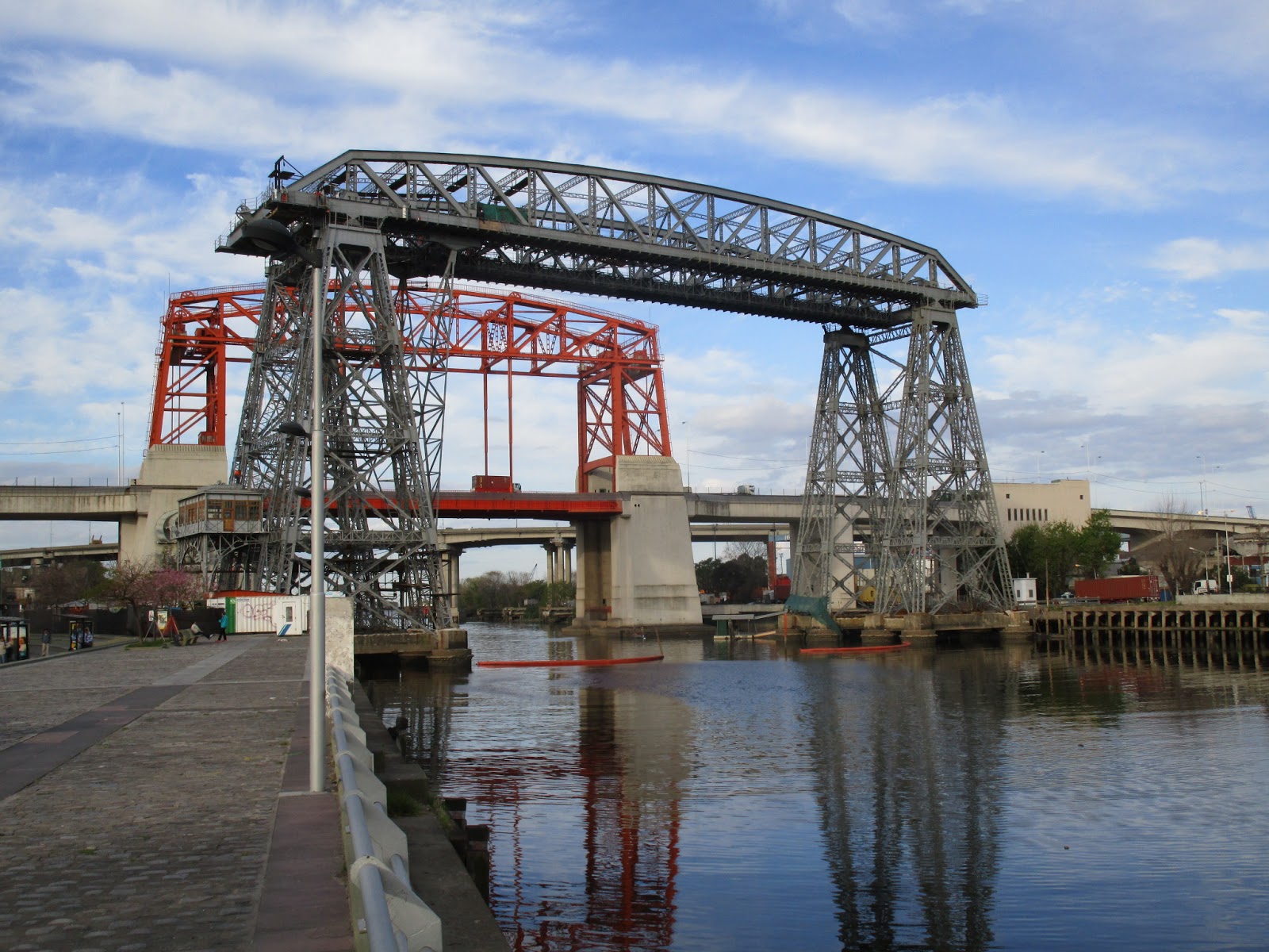
Walked south and east of the centre towards La Boca, along Puerto Madero. This is the old (disused) transporter bridge across the dock, with the motorway bridge in the background:

There isn't much to see at La Boca apart from the football stadium, and the Carminito - a small area of brightly coloured buildings along the river, which is just another tourist trap selling cheap souvenirs:


Wednesday 14th October
Directly opposite my hotel I noticed that there was another exhibition about Eva Peron, in a trade union headquarters building. It was even more interesting than the museum about her that I'd visited yesterday, because of the sheer volume of artifacts and photos on display, and also because a lot of the explanations were in English:

I took a last walk down Avenida de Mayo as far as the Congress building which is where the Arentine parliament sits:

I then made my way to the domestic airport, Jorge Newbery, and caught a plane for the one and a half hour flight to Puerto Iguazu, right at the north-eastern most tip of Argentina, where I will visit the falls tomorrow.
Stayed in the Royal Iguazu hotel which was comfortable enough.

Thursday 15th October
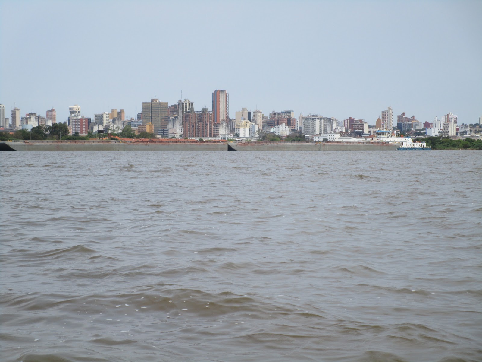
Puerto Iguazu lies on the Argentine side of the junction betwen the Parana and Iguazu rivers. The massive collection of some 275 waterfalls lies about 20 kms east, on the Iguazu river between Argentina and Brazil. Paraguay lies across the other side of the Parana river, to the west.
This photo, taken from the shoreline of Port Iguazu, shows the Paraguayan shoreline on the left side, across the Parana river, and the Brazilian shoreline on the upper right side, across the Iguazu river:

Some research on Facebook had revealed that there was to be a street skate at 11am starting in the north of the city, and I was looking forward to meeting some of the local skaters. On the subway ride there, however, I checked the event webpage using the free wifi available on the Buenos Aires metro, and found that it had been cancelled, owing to rain forecast for later that day.
I decided to go on to the start place and see if any skaters were there, but there weren't any so I went for a good long skate by myself, taking in the extensive parklands that stretched back towards the centre - which had a decent network of bike paths. There were lots of skaters especially around the large lake, and even a few slalomers:


It wasn't a great day for taking good photos, but I did stop at the obelisk on Av. 9 July to try and capture the scale of this huge avenue, said to be the widest in the world:

By now the rain had started, only a light shower but the tiled pavements were far too slippery to skate. I was close to the hotel so left the skates there and walked further down the Av de Mayo towards the Casa Rosada (Pink house) at the end of Plaza de Mayo, scene of many turbulent events in Argentina's history, including bombing by its own military during various coups d'etat.
There's a memorial to Argentine soldiers who died in the Falklands War, although this isn't the official one - which will be visited later:

The Casa Rosada, home to the Presidential offices, is the large pink building in the background of this photo:

I joined the queue to get in for a guided tour:

It was worth seeing inside, especially for several displays showing the Falkland Islands as Argentine territory:

This was the only room where photography was allowed:

Next stop nearby was the Bicentenial museum which was about Argentina's political history, it had some good exhibits but all the information was in Spanish unfortunately:

From there it was a short distance to Puerto Madero, an old disused dock area which has been redeveloped with many new restaurants and art galleries. This pedestrian bridge across the dock is said to have been inspired by the shape of a couple tango dancing:

Dinner was at this popular parrilla (grill) restaurant in San Telmo, a historic area just south of the city centre, which has narrow cobbled streets:

Monday 12th October
It was much warmer than yesterday, a pleasant spring day, ideal for strolling around and taking in the sights. Buenos Aires is certainly an attractive, well laid out city, full of attractive buildings and monuments, and plenty of green spaces. It's quite clean, with relatively few homeless people compared to the other cities I've visited on this trip.
Everywhere you go there are people asking if you want to change money at unofficial rates - which are apparently 50% higher than the official rate. I wish I had taken some US dollars with me as they are evidently in huge demand, it seems that Argentinians have very little faith in their own currency, hardly surprising given their history of numerous defaults and hyperinflationary episodes.
From the hotel I walked north towards the Retiro district, an upmarket residential area, where I found the official Falklands War memorial:

Somewhat ironically, just across the street from the memorial is this ornate tower built by English residents of Buenos Aires a century ago, and which was originally called the English Tower:

Next stop was the 18th century Basilica de Nuestra Senora de Pilar, a beautifully restored old Jesuit building with a magnificent Baroque silver altarpiece. Next door is Recoleta cemetery, the resting place of many Argentine celebrities, including the embalmed remains of Eva Peron, buried under her maiden name of Duarte, in this typically ornate mausoleum:


Following the military coup shortly after her death, her body was removed to a secret grave in Italy where it lay for 16 years before being returned to Argentina.
All the graves in the cemetery are highly elaborate and large:

Heading back towards the centre I passed by the Teatro Colon, the principal theatre of Argentina:

The 67 metre obelisk on Av 9th July was built in 1936, and is the place where football fans gather to celebrate their team wins:

Also on Av 9th July is this curious "mini Iguazu Falls" display. I'm going to the real thing after Buenos Aires, so didn't bother to risk getting soaked by approaching too close to this version:

The evening's entertainment was a Tango show at the Luis Borges cultural centre, not far from my hotel. It was really enjoyable, amazing dancing and excellent music and singing too. Following this I had a very late evening meal, starting at around 11pm - that's quite early by Argentinian standards.
Tuesday 13th October
Another fine warm day, which I again spent walking around various sights. I had breakfast at the famous Cafe Tortoni, just a few doors from my hotel, a Buenos Aires institution where Luis Borges and other Argentine cultural luminaries used to hang out. There was a queue to get in and the service was very slow:

Here's another view of Av 9th July, looking west. The white building with the antenna on top is the Ministry of Health, and it has a large image of Eva Peron addressing the crowds:

In search of more culture, as ever, I whiled away an interesting hour or so in the Eva Peron museum, in this building which was formerly one of many social welfare centres that Peron herself set up:

It's clear that she and her husband are still held in very high regard here, judging by the many visitors that the museum attracts. It had a good restaurant, where I had lunch.
Walked south and east of the centre towards La Boca, along Puerto Madero. This is the old (disused) transporter bridge across the dock, with the motorway bridge in the background:
There isn't much to see at La Boca apart from the football stadium, and the Carminito - a small area of brightly coloured buildings along the river, which is just another tourist trap selling cheap souvenirs:


Wednesday 14th October
Directly opposite my hotel I noticed that there was another exhibition about Eva Peron, in a trade union headquarters building. It was even more interesting than the museum about her that I'd visited yesterday, because of the sheer volume of artifacts and photos on display, and also because a lot of the explanations were in English:

I took a last walk down Avenida de Mayo as far as the Congress building which is where the Arentine parliament sits:

I then made my way to the domestic airport, Jorge Newbery, and caught a plane for the one and a half hour flight to Puerto Iguazu, right at the north-eastern most tip of Argentina, where I will visit the falls tomorrow.
Stayed in the Royal Iguazu hotel which was comfortable enough.

Thursday 15th October
Puerto Iguazu lies on the Argentine side of the junction betwen the Parana and Iguazu rivers. The massive collection of some 275 waterfalls lies about 20 kms east, on the Iguazu river between Argentina and Brazil. Paraguay lies across the other side of the Parana river, to the west.
This photo, taken from the shoreline of Port Iguazu, shows the Paraguayan shoreline on the left side, across the Parana river, and the Brazilian shoreline on the upper right side, across the Iguazu river:

Before getting the bus to the falls, it was necessary to replenish my supply of Argentine pesos. On arrival at the bank, however, I saw this somewhat daunting queue, which looked remarkably as though some kind of a bank run was in progress:

At least the queue was for the actual bank tellers, not the ATMs, so I was able to withdraw the cash I required without delay, and was on the bus to Iguassu Falls by 8.30 am, arriving about half an hour later to the Argentine side of the falls.
The queue to get inside the national park didn't take long, once inside there was a short wait for the little train that takes visitors up to the trails that lead to the falls. There are 2 trails, upper and lower and each give fantastic views over the many separate falls that comprise Iguassu.
I don't have sufficient words at my disposal to effectively describe the wonder and magnificence of Iguassu Falls. All I can do is present here some of the many photos I took and let them speak for me. It really is an awesome spectacle and I am so glad I have seen it.


I took the boat trip under the falls, and of course got soaking wet:


Outside the various restaurants there are lots of coatis scavenging for food. There are lots of signs urging people not to feed them, but inevitably these go unheeded:

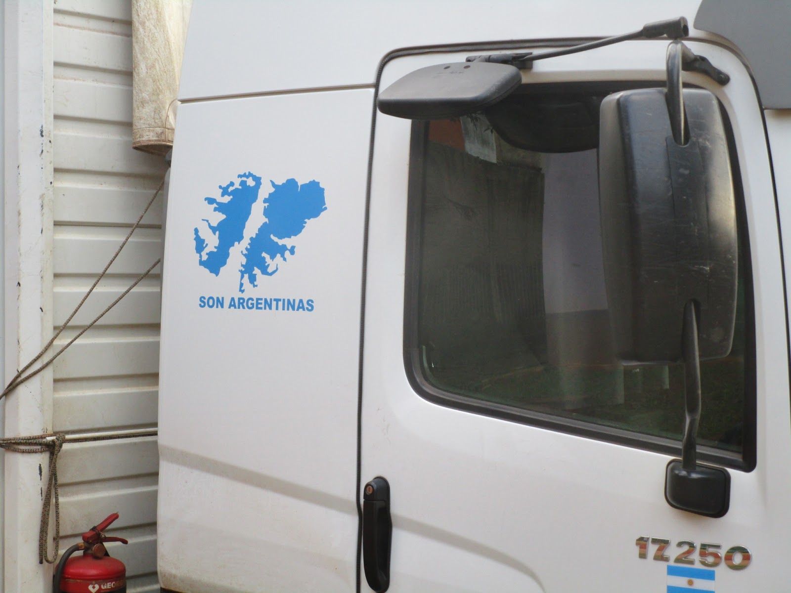
On the way back to Port Iguassu I saw this motif on a truck, further evidence of how widespread is the belief that the Falklands rightfully belong to Argentina:

Shortly after arriving back at the hotel there was a massive hailstorm. It didn't last very long but I was glad that I hadn't been out in it, the hailstones were the size of golf balls:


Friday 16th October
I got the 8.10 bus over to the Brazilian side of the falls, to appreciate the viewpoint from there, which is even better than from the Argentine side:


I got the bus back to Port Iguazu at 1pm and had lunch before getting the next bus over the Paraguayan border to Ciudad del Este, where I had planned to visit the Itaipu dam, as every Friday evening there was meant to be a special light show there, however when I arrived I found out that they were no longer doing evening light shows, but tours were still available during the daytime.
I checked into the Convair hotel, a comfortable modern building in the centre of town, where I was greeted with a welcome caipirhana cocktail.

Ciudad del Este is an ugly, modern city - the second largest in Paraguay, which has a reputation for harbouring terrorists - it's said that Osama bin Laden spent some time there in the period leading up to 9/11 - and certainly didn't feel like a safe place to wander around at night, not that there was anything worth seeing in the town anyway. So I made full use of the hotel facilites and had dinner there as well.

At least the queue was for the actual bank tellers, not the ATMs, so I was able to withdraw the cash I required without delay, and was on the bus to Iguassu Falls by 8.30 am, arriving about half an hour later to the Argentine side of the falls.
The queue to get inside the national park didn't take long, once inside there was a short wait for the little train that takes visitors up to the trails that lead to the falls. There are 2 trails, upper and lower and each give fantastic views over the many separate falls that comprise Iguassu.
I don't have sufficient words at my disposal to effectively describe the wonder and magnificence of Iguassu Falls. All I can do is present here some of the many photos I took and let them speak for me. It really is an awesome spectacle and I am so glad I have seen it.


I took the boat trip under the falls, and of course got soaking wet:


On the way back to Port Iguassu I saw this motif on a truck, further evidence of how widespread is the belief that the Falklands rightfully belong to Argentina:
Shortly after arriving back at the hotel there was a massive hailstorm. It didn't last very long but I was glad that I hadn't been out in it, the hailstones were the size of golf balls:


Friday 16th October
I got the 8.10 bus over to the Brazilian side of the falls, to appreciate the viewpoint from there, which is even better than from the Argentine side:


I got the bus back to Port Iguazu at 1pm and had lunch before getting the next bus over the Paraguayan border to Ciudad del Este, where I had planned to visit the Itaipu dam, as every Friday evening there was meant to be a special light show there, however when I arrived I found out that they were no longer doing evening light shows, but tours were still available during the daytime.
I checked into the Convair hotel, a comfortable modern building in the centre of town, where I was greeted with a welcome caipirhana cocktail.

Ciudad del Este is an ugly, modern city - the second largest in Paraguay, which has a reputation for harbouring terrorists - it's said that Osama bin Laden spent some time there in the period leading up to 9/11 - and certainly didn't feel like a safe place to wander around at night, not that there was anything worth seeing in the town anyway. So I made full use of the hotel facilites and had dinner there as well.
Saturday 17th October
I got a bus over to Itaipu Dam, about 15kms north of Ciudad del Este, which is the world's largest hydro-electric power plant, producing almost 90% of Paraguay's electricity and around 19% of Brazil's.


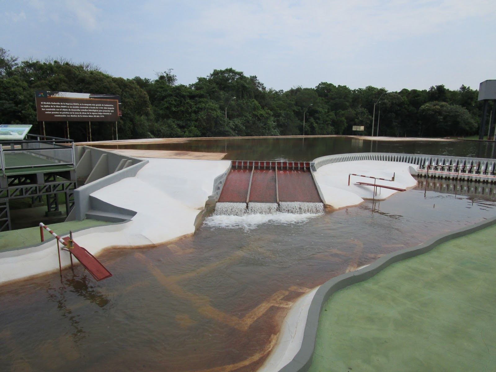
At the visitors centre there's a 1/100th scale model of the dam complex:

It didn't take long to do the tour and I was back in Ciudad del Este in time to catch the 1140 bus to Asuncion, a journey of around 300kms. The bus was very luxuriously appointed, with armchair-like seats, the widest I have ever seen on a bus - just as well, because I had an extremely fat person occupying the seat next to me, for the entire 6 hr journey:

Arriving in Asuncion around 5.30pm I took a taxi to my hotel, the Palmas del Sol just on the edge of the old city:

A big Oktoberfest was getting under way in the city centre and there were a lot of street parties going on:

I had dinner in Paraguay's oldest restaurant, the Bar San Roque where I enjoyed a tasty Paraguayan pork dish. Then it was back out onto the streets which were absolutely heaving with revellers enjoying the Oktoberfest, there was no option but to join in.
I got a bus over to Itaipu Dam, about 15kms north of Ciudad del Este, which is the world's largest hydro-electric power plant, producing almost 90% of Paraguay's electricity and around 19% of Brazil's.


At the visitors centre there's a 1/100th scale model of the dam complex:
It didn't take long to do the tour and I was back in Ciudad del Este in time to catch the 1140 bus to Asuncion, a journey of around 300kms. The bus was very luxuriously appointed, with armchair-like seats, the widest I have ever seen on a bus - just as well, because I had an extremely fat person occupying the seat next to me, for the entire 6 hr journey:

Arriving in Asuncion around 5.30pm I took a taxi to my hotel, the Palmas del Sol just on the edge of the old city:

A big Oktoberfest was getting under way in the city centre and there were a lot of street parties going on:

I had dinner in Paraguay's oldest restaurant, the Bar San Roque where I enjoyed a tasty Paraguayan pork dish. Then it was back out onto the streets which were absolutely heaving with revellers enjoying the Oktoberfest, there was no option but to join in.
Sunday 18th October
Spent the day exploring the city of Asuncion, starting off with a skate along the Costanera, the road along the waterfront. The city is set on a broad bay on the Paraguay River, and it has a small sandy beach, although swimming in the river is not recommended:

Along the Costanera is situated the Palacio de Gobierno, the seat of Paraguay's government:

There is a favela between the city centre and the waterfront, where it is apparently unsafe to venture:

From the port nearby I took a 20 minute ride across the wide river in this small boat, to the village of Chaco I, from where there were great views of the city:

Back in Asuncion, this is the old railway station, now disused:

This is the Pantheon of Heroes, one of Paraguay's more distinctive buildings, currently undergoing restoration. It contains the remains of several former presidents.

Other notable buildings are the Cabildo, the former home of the national congress, now a museum :

-the Cathedral, which is fairly plain and ordinary:

-and the Casa de la Independencia, one of the oldest buildings in Paraguay, where the architects of Paraguayan independence met secretly to discuss their plans:

By now it was getting towards sundown, and time to wander over to La Casa del Mojito, a lovely roof terrace bar serving exquisite herb-infused cocktails:

With beautiful views over the river, and relaxing music courtesy of a very talented guitar player/singer, this was certainly a good place to while away an hour or two before dinner.
Monday 19th October
It was time to say goodbye to Paraguay and move onto Bolivia, the next stop on the itinerary being Sucre, but in order to get there by plane, I had to take 2 flights, the first being to Santa Cruz. The flight from Asuncion arrived in Santa Cruz at around 10am and the flight onward to Sucre wasn't due to depart until 4pm so there was plenty of time to get the bus into Santa Cruz and have a look around; actually there is very little worth seeing there.
Santa Cruz was an isolated frontier town until the mid-20th century, and has grown rapidly since then, fuelled by oil and gas exploration, and massive agricultural development. There's not much of the old colonial city left, just a pleasant central square which still has a few historic buildings including the cathedral:


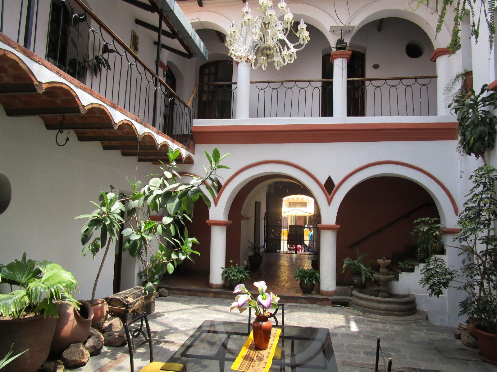
The second flight of the day, from Santa Cruz to Sucre lasted only 30 minutes, and the bus journey into the centre didn't take long. I found accommodation in the Hotel Recoleta del Sur, very near the town centre:
Sucre is renowned as the most beautiful city in Bolivia. It's a UNESCO world heritage site, and has some of the finest Spanish colonial architecture in South America. Set in a broad valley at an altitude of 2800m above sea level it enjoys a spring-like climate the whole year round. The city was founded in 1538, and became the capital when Bolivian independence was declared in 1825. After both the congress and the presidency moved to La Paz in 1899, Sucre remained the seat of the Supreme Court and so has been allowed to retain the title of official or constitutional capital.
Tuesday 20th October
After breakfast I took a bus ride about 5kms out of town to Parque Cretacico, home to the world's largest collection of dinosaur footprints, discovered in the 1980s by workers at the adjacent cement works and limestone quarry. Some 5000 footprints, from at least 150 different dinosaur species, were preserved through sedimentation. The rock surface was subsequently pushed up through collision of tectonic plates, so that it's now near vertical. During the quarrying process the surface was exposed again and subsequent erosion of the sedimented rock face has exposed the footprints again.
The whole site has been turned into an exhibition centre, with quite a few life size models of dinosaurs:

The Sauropod model is 36 metres long and you get to walk underneath it:


This is the exposed rock surface with the footprints. There are a number of binoculars available t view them close-up.


On display inside there's a T Rex model, with plaster casts of the various types of footprint:

From outside the exhibition there are fantastic views over the city:

Back in the town centre, the Plaza 25 de Mayo is the main square has a number of important historic buildings, the most notable being the Casa de la Libertad, originally a University built by the Jesuits, and where the Bolivian Act of Independence was signed in 1825.
This is the actual room where the document was signed, and all the furniture was in place at the time of the signing. On the wall are paintings of the prime architects of independence, Simon Bolivar being the central figure:

Also on the square are found the Cathedral and the Prefecture:

A 20 minute walk up the hill to the Recoleta square was rewarded by more fine views over the city:


There are lots of stalls like this one selling sweets, biscuits and cakes wherever you go. Bolivians certainly seem to like sugar, though that's not how Sucre got its name, it's named after one of their revolutionary leaders. It's obviously no coincidence that there are also a huge number of dental surgeries in the town:

The sky was starting to turn very dark and a storm was imminent. I managed to get back to the hotel just before the heavy rain started. After an hour or two it stopped raining and I went out to dinner at La Taverna, said to be the best restaurant in town, which certainly lived up to expectations.
Wednesday 21st October
After breakfast I caught a bus to Potosi, a journey of around 3 hours that involved climbing from 2600m in Sucre, to 4060m above sea level. Potosi is said to be the highest city in the world, and it owes its existence to the huge conical mountain, Cerro Rico (Rich Mountain) adjacent to it, where the world's richest source of silver was discovered in 1545. This find triggered a massive silver rush and Potosi's population quickly grew to 100,000, making it easily the biggest metropolis in the Americas, and rivaling the size of major European cities at that time.
On arrival there the increase in altitude was instantly noticeable and it took some effort to walk up the steep hilly street leading from the main plaza towards my accommodation:

Potosi Plaza with Cerro Rico in the distance

The mountain dominates the view along the narrow city streets

Hotel Eucalyptus


During the informative tour of the museum, the guide explained that the "$" symbol used to denote many different world currencies actually originated in Potosi, evolving from a symbol which originally used the letters PTSI superimposed upon each other, and which was engraved on all the coins produced here.
After the museum tour I went back to the hotel to enjoy the view from the rooftop terrace, where there was a clever little lift system by which drinks could be delivered from the bar downstairs, with an intercom system allowing orders to be placed:


From the terrace there were great views over the city and Cerro Rico:


Dinner was at Cafe 4060 - no prizes for guessing how this restaurant got its name. Then a fairly early night as I was quite tired from the altitude effects.
Thursday 22nd October
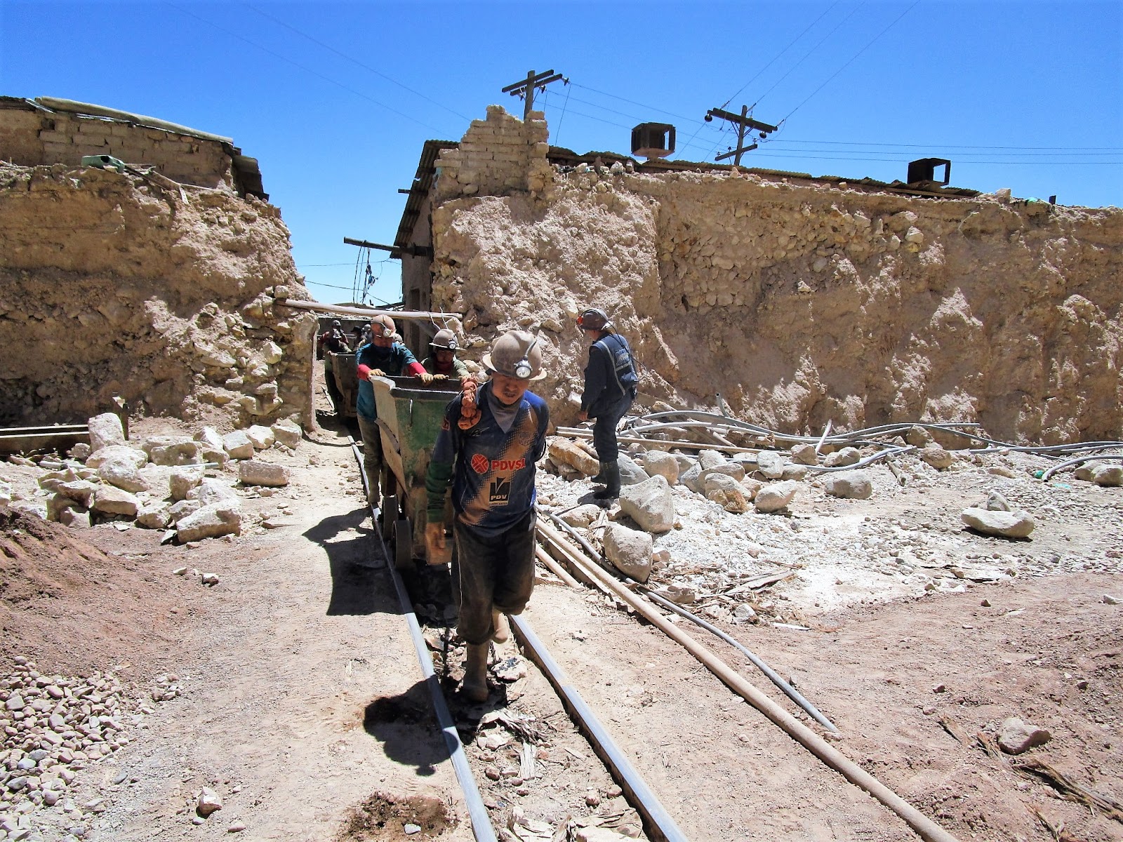
Feeling a bit more comfortable with the altitude I took a tour down the Potosi Silver mine, with Koala tours. I was collected from the hotel at 9 am and, with 2 other tourists, was taken by minibus firstly to the miners market at the base of Cerro Rico, where we bought dynamite, fuses, fizzy drinks, and coca leaves as presents to take for the miners. Then we were given helmets, boots, and protective clothing and taken to the mine entrance.

Dynamite and fuse ready
Before going into the mine we were shown the equipment used to grind the mined mineral ore into slurry from which the silver is extracted:


It was all very primitive, with no health and safety precautions at all.
The mined ore is transported out of the mine in these open trucks, puched by miners along rails:


Entrance to the mine
We were led about 1km along a tortuous system of narrow tunnels, then descended through a series of shafts to a depth of 80m. It was really difficult getting through some of the descending shafts, which had only rudimentary ladders, and at times felt very unsafe:


After about an hour, but which seemed a lot longer, we were 80 metres below the surface and were able to see some miners at work. We gave them their presents and talked to them for a while about conditions in the mines, it is certainly a tough life but for a large proportion of the population there would be no other option, silver mining has been the main industry here for over 450 years.


It was a big relief to emerge from the mine, after a long climb back up to the surface:

The tour was very worthwhile and certainly gave a good insight into the daily life of the thousands of miners in Potosi. I've been on other mine visits, to coal mines, gold mines, opal mines, but these were all very safety conscious and geared to being a tourist experience; visitors to Potosi have to put up with the same conditions and dangers as the real miners and it is much more authentic.
After removing all our protective gear we were taken back to our hotels, and following a much needed shower I spent the rest of the afternoon wandering around the city:


After dinner (llama steak at a small restaurant whose name I can't remember) I boarded the 8.45pm bus to La Paz. Similar to the other long-distance buses I've been on here, this was very comfortable, with wide seats that reclined almost fully, and very importantly had good heating - temperatures at this altitude drop to almost freezing at night.
Friday 23rd October
The bus arrived in La Paz at 5.30am. It was predictably very cold at that time in the morning. I had booked accommodation in a nearby hotel, the Cordillera Real, and fortunately they had my room ready when I got there, so I was able to get a few hours sleep, waking up at 11am by which time the temperature had risen to a very pleasant 20 degrees.

The hotel was on a very steep street, typical of most streets in La Paz
It was a 10 minute walk downhill to San Francisco square, which gets its name from the adjacent colonial church, which has a richly decorated facade:

At the side of the church, Sagarnaga St is a typically narrow, steep thoroughfare that is the centre of the tourist area, it has lots of shops selling brightly--coloured handicrafts and fabrics:

Many women can be seen wearing the traditional Aymara costume of billowing skirt, brightly coloured carrying shawl, and funny bowler hat perched on top of their head:


Nearby is the Coca museum, an exhibit all about the history of the coca leaf, its importance in traditional Bolivian culture, and the way it's use has been altered by western influences. It was very balanced and informative, and there was a cafe attached where I was able to try coca liquor which certainly packed a punch.

Also close by is the "witches market" where there are shops selling bizarre potions of all kinds to fend off various spirits. The dried llama foetuses seen hang up are buried in the foundations of new buildings, supposedly to make them safe from falling down - a very real danger in such a hilly city.

From here I walked south and downhill along the Prado, a wide boulevard lined with more modern buildings:

This leads to Sopocachi, the middle class district of La Paz, where there wasn't much of interest. However, climbing uphill from there I reached one of the stations on the city's brand new Telecabin system, opened only last year. There are currently 3 lines, with 3 more planned. I rode one of the cabins up to El Alto, the satellite city above La Paz, enjoying the fantastic views:

Higher up, the crude dwellings are simply piled on top of each other in a typical shanty town way, clinging to the steep mountain side:


View from the top of the telecabin
El Alto is a huge district and mostly very poor. It isn't really recommended for tourists to go there. However I wanted to check out another telecabin route leading down from another point in El Alto, about 4 kms away, so set off to walk, it didn't take too long. There were some interesting markets on the way, almost all the women were wearing the traditional costume:

Outside the next telecabin station were some young llamas:

The journey down on the other telecabin was just as exciting as the ascent:


This telecabin led down to the centre of town, next to the former railway station which is now a museum. The ultra modern new telecabin infrastructure certainly stands out among the mostly shabby old buildings that characterise the rest of the city.
Saturday 24th October
I awoke at 7am and after breakfast at the hotel, walked down to the office of Vertigo Tours, where I had booked the all-day trip to cycle the famous "Death Road" in the Yungas mountains, a 3500 metre descent along a largely single-track road, often the width of just a single vehicle, with few guard rails to protect travellers from going over cliffs of up to 600m. Over the years hundreds of people have lost their lives on this highway, and it was named the "World's Most Dangerous Road" in 1995. Since then a new highway has been constructed which takes virtually all the motor traffic, so the old road has become a popular route for mountain biking descents. There are dozens of companies in La Paz which specialise in taking tourists, with hire bikes, by minibus up to La Cuembre Pass at 4650m, where, following a safety briefing, they can hurtle down to Corioco, at just 1200m.
The party consisted of myself plus 2 other tourists, 2 guides (front and rear) and a driver. The bikes and protective gear were all carried in a rack on top of the bus.
It took about 2 hours to drive up to the start of the ride, during which time we all got to know each other, and our guide told us about the history of the road, how it was built by prisoners of war in the 1930's, and lots of interesting stories about how it came to be known as "The Death Road".
On arrival, we were glad to put on all our protective clothing, as the 4650m altitude ensured that it was very cold. We were given a final safety briefing, allowed to try out the bikes for size and adjustment, then we each had to perform a ritual to honour Pachamama, the Andean goddess of the mountain, to ensure a safe journey down. This involved pouring what seemed to be neat alcohol over our brake cables...

...then taking a swig of this extremely strong liquor -

Now we were ready to go!

After a few kms we stopped at this cliff edge for a photo:

...and another one a bit further on:

These photos give an idea of what the road was like:


This cross marks the spot of the worst ever accident on Death Road, where an overloaded bus plnged over the edge killing over 100 people:

End of the ride - down at 1550 metres it was a lot warmer

We all made it down safely! It actually didn't seem all that dangerous, however there were a number of memorials to cyclists who'd gone over the edge, apparently a few die every year.
I was still in need of more adrenaline so took the option of a side visit to the nearby attraction known as Zzip The Flying Fox - 3 interconnected ziplines each about 500m long:


This was great fun, and not nearly as terrifying as I had imagined. You reach a maximum speed of about 85km/hr so it's all over quite quickly, unfortunately. Here's a :video :
After this we were taken to a nearby hotel for a late lunch, then began the drive back to La Paz, a journey of nearly 3 hours. It was after 8pm when I got back, by which time I was quite exhausted, after a very exciting and thrilling day.
Sunday 25th October
I'd considered going for a day trek in the mountains nearby, but the weather was overcast and looked like rain was imminent, so I explored a few more areas of La Paz. I walked up a very steep hill from my hotel towards the Cemetery district, and there were colourful market stalls all the way along the route.

The huge cemetery had a mixture of elaborate tombs, like the gothic style example on the left, and row after row of graves stacked on top of each other. The building in the background on the right of the picture, which looks like a 1960s council housing block, is a multi-storey version of the stacked graves in front of the picture. Note the telecabins above:


Since there was a telecabin station close by I decided to ride up to El Alto again just for the view, despite the poor visibility it's still an amazing experience:

On the left of this photo, about 2/3rds of the way down, you can see a crushed car that went over the cliff edge and somehow got wedged in one of the fissures in the mountain surface:


El Alto station
At El Alto there was a huge market going on right outside the station so I went to have a look around. It was extremely crowded and I shouldn't have risked wandering around an area known to be unsafe, I foolishly allowed myself to become distracted by the colourful and busy surroundings and my mobile phone got swiped from my pocket. I realised instantly that something was missing but it was too late, the thief had disappeared into the crowd. It could have been worse - the phone is insured, and I'd rather have lost that than my wallet and bank cards which were in my other pocket.
Later in the afternoon I went to a show called "The Fighting Cholitas" - a rather cheesy display of Mexican style wrestling, where men in ridiculous lycra outfits wrestle with women wearing Amayra traditional costume (they do take off their bowler hats first):

After wrestling with the men, the women wrestle each other:

They all threw each other around and kicked each other a lot, but nobody seemed to get hurt!
Had my photo taken with one of the combatants at the end of the show:

Monday 26th October
Had to go to the police station in the morning to report the theft of my phone yesterday. On the way there I went past the Calle Jaen, La Paz's most original colonial street:

Then onto the Plaza Murillo, the city's main square. on which stand the Metropolitan Cathedral and the Presidential Palace:


It didn't take long to report the theft, and I soon was in the nearby Parque Urbano Central, which gave an excellent view over the city centre, with El Alto above in the distance:

From there I walked back towards the centre, along the tree-lined Prado:

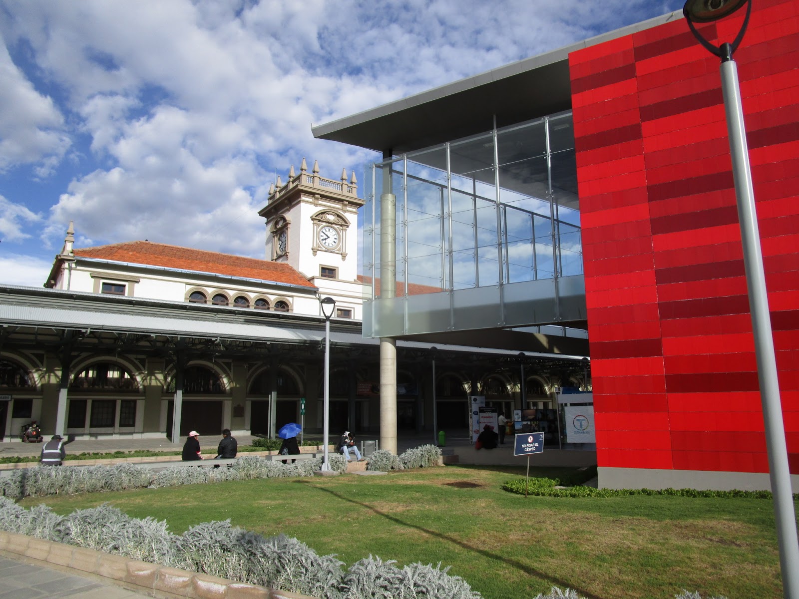
The huge bus terminal is noteworthy on account of having been designed by Gustav Eiffel:

Tuesday 27th October
I got a taxi to the bus terminal by the Cemetery, where the next bus to Copacabana, on Lake Titicaca, was about to depart:

The hat of the woman sitting next to me kept falling off every time the bus went round a corner, and it always ended up in my lap, much to my amusement:

On reaching the eastern shore of the lake after almost 3 hours winding through the mountains, the bus crosses by ferry over the narrow strait at Taquina, and passengers all have to get off the bus and board a separate ferry. You can see the bus ferry already crossing, in the distance:


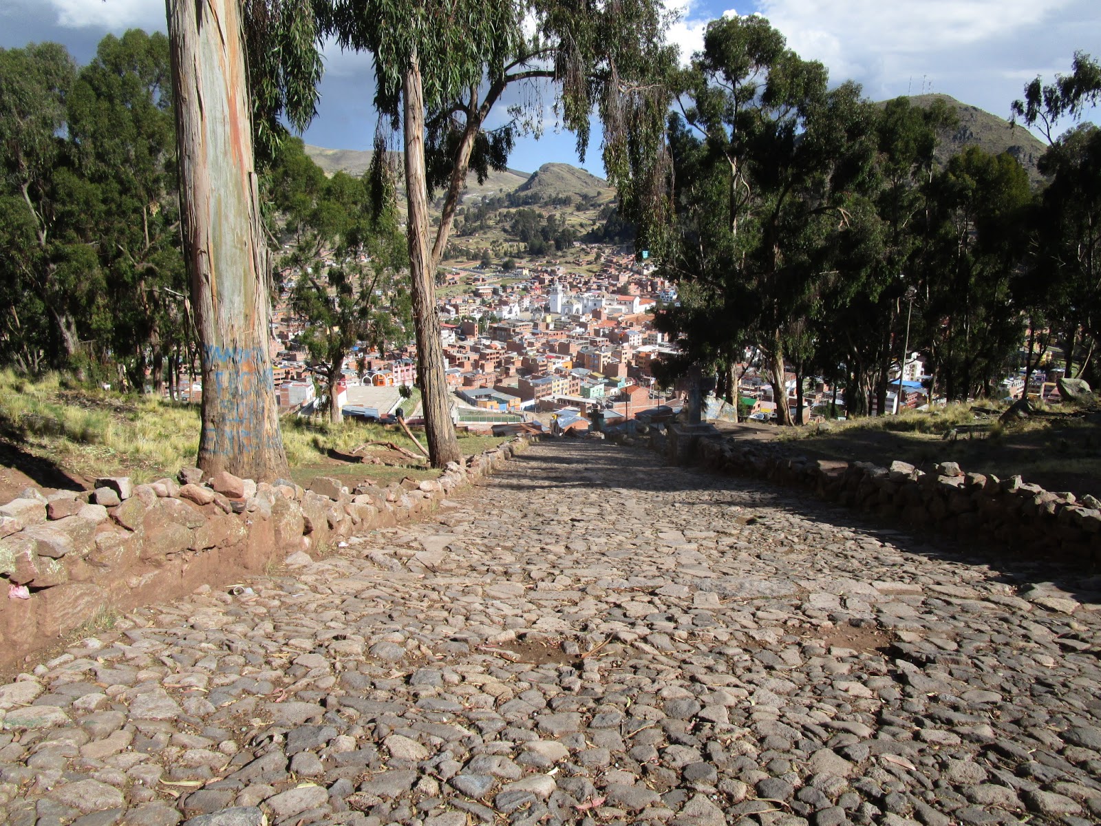
When the bus arrived we re-boarded it and it was only another half hour to Copacabana, a pleasant little town on the shore of Lake Titicaca, and the access point for visiting its sacred islands.
The cathedral contains Bolivia's most revered image, a statue of the Virgen de Copacabana (photos not permitted) so the town attracts hordes of Catholic pilgrims at certain times of the year. Therefore there are plenty of hotels and restaurants and I had no difficulty in finding accommodation at the Hotel Utama which was comfortable enough, and well heated - an important consideration at this altitude (3870m).

Copacabana Cathedral

Hotel Utama
The other main religious site is Cerro Calvario, a steep hill that rises above the town. The trail up the hill follows the stations of the Cross up to the summit at 3973m:


Being by a huge lake the restaurants offered a good variety of seafood and I had an excellent Kingfish cebiche, accompanied by a few equally enjoyable pisco sours.
Wednesday 28th October

Departure from Copacabana
The overloaded ferry was painfully slow and it took almost 2 hours to travel the 12km to Challapampa, the northermost settlement of the island. By this time the temperature had warmed up nicely and a beautiful day lay ahead:

Leeading from Challapampa there's a well-marked trail, paved to resemble an old inca road, leading to Chincana, a ruined Inca complex of interlinked rooms and plazas:


From here another trail leads along the central ridge of the island, at just below 4000m, for about 7km to Yumani, its southernmost settlement:


In one of the very few shaded areas of the trail, snow still lay on the ground:

At one point the path was blocked by two llamas:

The descent into Yumani was down a very steep rough path, which some donkeys were struggling up:

At the end of the trail there was time for a beer before catching the ferry back to Copacabana:

I arrived back at 5pm, collected my luggage from the hotel, and an hour later was on the bus to Puno, on the Peruvian side of the lake. About half an hour out of Copacabana the bus stopped at the border and everyone had to disembark, have their passports stamped to exit Bolivia, then walk 300m across the border to have a Peruvian entry stamp, the whole process took about half an hour.

The bus arrived in Puno around 8.30 local time (an hour behind Bolivia) and I got a taxi into the centre of town, checked into the very comfortable Puno Terra hotel, close to the main plaza and had another very good meal in one of the many restaurants nearby.
Thursday 29th October
Puno is Lake Titicaca's main port, and quite a busy town. The main plaza is an attractive place, its large cathedral having a richly detailed facade somewhat similar to the San Francisco church in La Paz:


Behind the plaza, a steep hill leads up to Huajsapata Park, where there is a statue of Manco Capac, the first Inca:


The Deustua arch, built to honour the heroes of the movement for independence
The steamship in the background of this photo is the Yavari, the oldest working iron ship in existence. It was built in Britain in 1862, and steamed its way over to the Peruvian coast where it was dismantled and transported in pieces across the Andes to Lake Titacaca by packs of mules and llamas, then reassembled and used as a naval gunship. It's now being restored as a museum but at present not open to visitors, unfortunately.

From the harbour I took a tour out to the Uros Islands, around 40 separate islands constructed from dried reeds, which float on the lake. Each island has up to 10 houses on it, also constructed from reeds:


The inhabitants exist largely through tourism, allowing people into their homes and selling souvenirs.


The tour included a ride in one of their traditional boats, also made from reeds:

Back in Puno, this woman was single-handedly pushing a broken down bus full of passengers:

Friday 30th October
Next stop was Cusco, about 450kms away. I got the bus a 8am, and it was another very luxurious one, the 7 hour journey passed quickly and comfortably. Arriving in Cusco I got a taxi to the El Pelegrino hotel, well situated right by the main Plaza, which had been recommended by a very nice Spanish girl called Nagore, who I met on the bus:

Obviously I wanted to visit Macchu Picchu and the other Inca sites in the region, and in order to do this you have to purchase various permits which involves queuing up at different offices. After an hour or so I had everything arranged and was ready to get started tomorrow. Before it got dark there was time to take a few photos of the main square, the Plaza des Armas. There was a big carnival procession in progress with a variety of interesting costumes on display:


I had a superb evening meal in the Calle del Medio, a restaurant next door to where I was staying - Alpaca with Ocas and Mashuas in Chimichurri sauce. And inevitably some pisco sours as well.
Saturday 31st October
I set off for Macchu Picchu, some 80kms from Cusco, and saw 2 important historic Inca sites en route. Firstly I took a local bus to Pisac, about 40kms from Cusco, where, high up above the town, at 3300m there are the ruins of a large Inca city. From the town I took a taxi up to the ruins - it was a very hot day and I was short of time.


The path back down to the town was quite steep, and rough in parts:


View along the Sacred Valley
From Pisac I took another local bus to Urubamba, then straight onto another bus to Ollantaytambo, another major Inca town, which is still inhabited and bears the original grid system of narrow streets:

Above the town are the ruins of a fortress and temple, and a large area of farming terraces:


The market square is full of stalls with brightly coloured Inca fabrics:

The road up the Sacred Valley ends at Ollantaytambo and from here the only access to Macchu Picchu is by rail. I caught the Inca Rail train at the station here, it is a 1hr 20 minute journey up to Macchu Picchu village.

Ollantaytambo station
The trains are very comfortable, with lots of windows allowing a panoramic view of the scenery:

I arrived at Macchu Picchu village around 5pm and had a wander around before it got dark; it's inevitably full of hotels and restaurants so i was very easy to find accommodation.


Inca statue in the main square
Sunday 1st November
There's a fleet of buses taking visitors from Macchu Picchu village, up the winding road to the ruins. Even at 7am there was a big queue for bus tickets:

The weather had become very cloudy and it even rained a bit while I was in the bus ticket queue. But by the time I arrived at the ruins, around 8.30am, it was clearing up and I decided to do the long hike up to the summit of Cerro Macchu Picchu, the tall mountain overlooking the site, hoping that by the time I arrived it would be clear and sunny and I would be able to enjoy fantastic 360 degree views.
The ascent, up a steep, uneven path, is meant to take about an hour and a half each way. However, about half way up it started raining so heavily that I was forced to shelter under some trees for almost an hour before the rain eased off. The clouds hadn't cleared by the time I arrived at the summit but it seemed a waste of effort to go straight down again without seeing anything, so, together with a crowd of other hikers I sat patiently under the small shelter, waiting for the clouds to disperse.


After about an hour it was possible to see Macchu Picchi in the distance below:


The path down was very slippery and considerable care was required:

Half way down, the visibilty improved further and at last all the hard climbing effort was rewarded with an amazing view:

It was 2pm when I arrived back at the base of the mountain and besides the main ruins there were two other sites some distance away which I wanted to see, and both required about half an hour walk each way. The first was to Intipunku, the main entrance off the Inca Trail, from where there were great views over the entire site:


Then I walked along the vertigo-inducing path to the Inca drawbridge, over another entrance to the complex along a narrow path that was built into a sheer cliff face:


There was still time to have a look around the main ruins:


A few llamas and also some chinchillas could be seen living there:


I wanted to stay longer but was booked on the 6.20pm train back to Ollantaytambo that evening, and I still had to queue up for the bus back to Macchu Picchu village, so after a few final photos it was time to head for the exit:


From Ollantaytambo station there were plenty of minibuses waiting to take passengers back to Cusco, a journey of about an hour and a half. So I was back in Cusco around 10pm after a very long, and exciting day.
Monday 2nd November
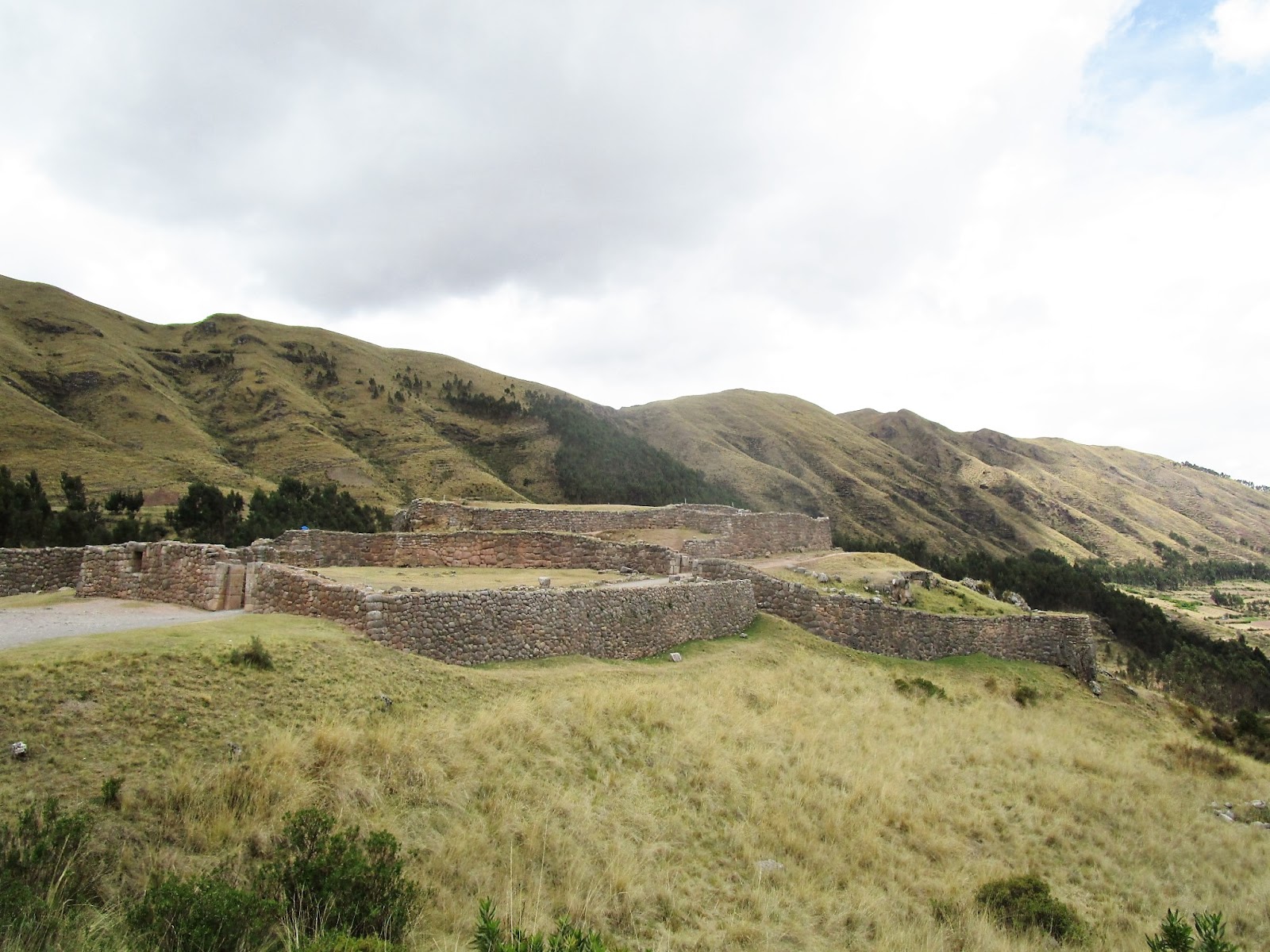
I had one more day in Cusco, so went to see four more historic Inca sites that are nearby. I got a colectivo bus towards Pisac, along the same route I took 2 days previously, and after 10 minutes uphill I got off at Tambomachay, a kind of Inca version of Bath, where 2 aqueducts provided spring water for ritual cleansing:

From there it was a downhill walk to the other sites. Nearby is Pukapukara, thought to have been a military fortress and also lodgings for visitors to the Tambomachay baths:
To reach the next site, Q'enqo, I walked across country for about 2kms following a narrow track. Cusco is visible in the distance:

Q'enqo was an important religious site where sacrificial llama blood was poured along various channels, and various omens regarding fertility were signified according to which way it flowed. It's a huge rock with a labyrinth through it, within which is an elaborate stone temple carved out of the rock:


The final, and most impressive of the sites, is Saqsaywaman, a massive fort high above Cusco, surrounded by 3 parallel zigzag walls constructed from huge boulders, some weighing over 300 tons:


Nearby is a large Christ statue, towering over a lookout towards Cusco:


A steep path leads downhill into the narrow streets of San Blas, the oldest part of the town:

From the main square it was a 10 minute walk to the memorial to Pachachutec, the Inca chief:

Inside was an exhibition of Inca culture, and there was a viewing area at the the top of the tower:

Tuesday 3rd November
I took a flight to Lima, departing Cusco at midday and arriving about an hour and a half later. It took about an hour for the taxi ride into the town centre, Lima's traffic is extremely congested and slow moving.
My hotel was in a historic building overlooking the Plaza San Martin. It looks a lot nicer from the outside than it was inside:


Nearby was the main square, the Plaza de Mayor, a UNESCO world heritage site, which is kept in beautiful condtion in contrast to much of the surrounding area. It is one of the largest squares in South America and has some impressive buildings, with unusual wooden balconies:


Behind the Plaza Mayor, the Rio Rimac, the river running through the city, has been drained and a massive engineering project was in process. Over the other side of the river is Cerro San Cristobal, the mountain with the cross on top at the left of this photo:

I took a ride on an open top tour bus around the centre but the traffic moved so slowly it would have been quicker to walk. And it got dark quite early so it wasn't possible to get any decent photos.
Dinner was at the Gran Hotel Bolivar, an historic establishment very close to where I was staying, which styled itself "The Cathedral of Pisco Sour" - and reputed to mix the finest cocktails in Peru. The Pisco sour I had there was certainly very good, although the food was a bit disappointing.
Wednsday 4th November
Lima, with a population of over 8 million, is one of the largest cities in the develoed world without a metro system, and consequently the roads are almost continuously choked. However there is a rapid bus system called the Metropolitano, running on dedicated bus lanes:

I rode one of these buses down to the Miraflores district, about 8kms from the centre, and from there it was a short walk to the Larcomar, a clifftop area overlooking the Pacific Ocean:

I'd brought my skates with me, on the off chance that the surfaces would be reasonably smooth, and indeed they turned out to be. All the way along the shoreline runs the scenic and well-paved Malecon.

I followed this south as far as the next district which is known as Barranco, in earlier days Lima's seaside resort, which has many attractive old houses, some of which are now museums:

The Bridge of Sighs


Skated back up to Miraflores and headed further north towards the port district of Callao. It was a really nice place to skate, with fabulous views all along the route:


There was a statue of John Lennon - though no explanation of what his connection is, or was, with Lima:

.
After skating around 20kms in what had been very humid conditions, I arrived at El Grifo - a former petrol station now turned into a restaurant specialising in modern Peruvian cuisine:

Here I enjoyed an excellent meal, beef with rice and beans cooked in a spicy sauce:
I skated back to the hotel, passing many fine buildings that had become sadly neglected:

The evening was a bit disppointing. I wanted to go up Cerro San Cristobal to enjoy the view from there oer the city while it was still daylight. I got on a tour bus heading up there, which was supposed to be leaving (from near Plaza Mayor) within 10 minutes, however it didn' set off until about an hour later, and with all the delays caused by the heavy traffic we didn't arrrive at the top of the hill until after dark. So no decent photos, sadly.
Thursday 5th November
I got up at 5.30pm and took a taxi to the airport in good time for an 8.30am flight to Santiago, then a conecting flight over the Andes to Mendoza, Argentina, where I wanted to do some wine tasting.
Argentina is 2 hours ahead of Peru and so I didn't arrive in Mendoza until around 4pm. After checking into the Hotel Confluencia I took a walk around this attractive city of around 1 million inhabitants. It's an elegant place, with trees lining all the streets. Because rainfall is quite low here, there's a system of canals running along the sides of the streets, which irrigate the trees. In some places these canals are uncovered, making this a hazardous place to walk around if you are blind or partially sighted:

There are many pretty squares and parks around the city. This is the Plaza Espana, which has a monument decorated with fine Andalucian tile work commemorating Spain's colonisation of South America:


The pretty, pedestrianised mall has many restaurants and bars, and a "malbec" fountain

The main square, Plaza Independencia
Although Mendoza is over 1000 miles south of Lima, and also 800m above sea level, the weather was much warmer, dry and sunny. Everyone there is very polite and courteous. Cars stop at zebra crosings and hardly ever sound their horn - the contrast with Lima couldn't be greater.
Mendoza has plenty of good restaurants and bars, and they stay open very late, going out to eat at 11pm is normal here, so that's what I did, enjoying a decent steak.
Friday 6th November
I took a public bus down to the Maipu wine region, about 10kms south of Mendoza. I hadn't realised that you're not able to buy tickets on the bus here and need a prepaid travelcard; but a kindly person on the bus let me use his card and wouldn't take any payment in exchange. People seem very courteous and well-mannered here.
It took about half an hour to get to Mr Hugo's bicycle hire where I rented a rather clunky bike, at least the gears and brakes worked, after a fashion - and armed with a rudimentary map showing the local wineries, all of which are in a 10km stretch along a main road, I set off to try as many as possible.

First stop was the Wine museum, which had a lot of historical wine making exhibits, and where I sampled the first malbec of the day, it was great.

On the way to the next winery I met up with 2 other cyclists and we spent the rest of the day travelling together around the different wineries, I can't remember exactly how many we covered but it was at least 5.

There was a segregated bike most of the way:

We were so busy cycling from winery to winery that I didn't have time to take any more photos - but we were sampling good wines steadily until the last one closed at 5pm, then got the bus back to Mendoza.
Saturday 7th November
On the recommendation of Rhiannon, one of the girls I met yesterday at Maipu, I booked a gourmet wine tasting tour with an outfit called Trout and Wine. I was collected from my hotel at 9am and met the tour guide, Ivan, and the other two guests, a nice couple from the US. In about half an hour we were in Lujan de Cuyo where we were to visit 4 wineries during the day.
At the first, Altavista, we were given a tour of the vineyards before sampling the wines. It was a beautiful sunny day and the snow-covered Andes made a stunning backdrop:

The tasting room was very posh with special spitting-out sinks:

Altavista is a large winery (or bodega as they call them there) and there were several massive cellars there:

At the next winery, Kaiken, there was a cut-away trench in the vineyard which you could walk into to see the different layers of soil, which made it easy to appreciate how older vines, with deeper roots, will engage with soil of a different constitution to younger ones with shallower roots, and thus the grapes they produce will yield diffeerent flavours:

Lunch was at the third bodega, Finca Agostino, and it was absolutely amazing. This was the menu:


Each course was paired with a different premium wine and it was a full glass each time. On top of all the wines we'd already tasted at the previous two places, by the end of this wonderful meal we were slipping into an alcoholic haze.
Besides tasting delicious, each course was very imaginatively presented. This is the second course, which was served on a melted and flattened-out wine bottle:

The fourth winery was also very good but by now I'd tasted so many lovely wines that it was harrd to distinguish between them.
I arrived back at the hotel around 6.30pm and after a brief rest decided to go out for a skate - I wanted to check out the large Parque San Martin on the edge of the town. Besides being very scenic and well landscaped, it also has a lot of smooth tarmac and I met a number of skaters there. They were very friendly and invited me to come for a drink afterwards. Not that I needed any more drink that day!

Slalom cones and smooth tarmac in Parque San Martin
Sunday 8th November
It was time to move onto Chile, via the scenic route - a 7 hour bus journey over the Andes, departing at 7.30am, I was lucky enough to be allocated a front seat upstairs on the bus, so was able to enjoy the fantastic scenery:

After about 3 hours we reached the Chilean border, and everyone had to get ooff the bus and queue up for exit and entry visas, a process which took about an hour:

Over on the Chilean side we passed by the ski resort of Portillo, closed for the summer:

Arriving at the Alameda bus terminal in Santiago around 3pm, I took a metro train into the centre and checked into the Paris Hotel:

By this time the weather had become rather overcast but it was pleasantly warm. It was a short walk from the hotel to the main square, Plaza des Armas, the focal point of which is the rather plain Cathedral:


Nearby, in a pleasant park alongside the River Mapocho, is the Museum of Fine Art, in an imposing neoclassical building:

A short walk further on led to Cerro Santa Lucia, the hill where Santiago was proclaimed in 1541, following a battle in which the indigenous forces were defeated by Pedro de Valdivia. During the 19th century the hill was transformed into a landscaped park, and a popular spot to climb up for views over the centre of the city:


There is a memorial to de Valdivia in the park:

Monday 9th November
I visited Valparaiso, Chile's principal port, situated about 120kms west of Santiago. It was easy to get there by public transport, buses leave every 15 minutes or so and the journey takes just over an hour and a half.
On the way to the bus station I passed by the central railway station, where the Christmas tree was already about to be put up:

Valparaiso has UNESCO World Heritage status on account of its many historic buildings, a legacy of the days when, prior to the construction of the Panama Canal, it was the major hub for ships travelling between the Atlantic and Pacific Oceans.
It's built on a series of hills, which have a number of "ascencores" - elevators - most of which are somewhat rickety but still afford an exciting way to get up to the city's many excellent viewpoints:


Most of the houses are painted in bright colours, and there are a lot of murals and graffitti:


There are lots of interesting buildings, this one, the Palacio Bablirizza, really stands out - zoom into the picture and you can see an amazing number of decorative features and motifs:


The main square, Plaza Sotomayor
I took a 30 minute trip around the harbour in this small boat:

...which passed close to these seals on a floating platform:

Got some good views of the bay:

... and the skipper entertained us with a few magic rope tricks.

Being on the shore of the Pacific there is a risk of tsunamis. Fortunately the many hills would provide a good escape route in the event of a major incident:

Unusually there are still trolleybuses running here:

There was still time to take a quick look at the seaside resort of Vina del Mar, a 10 minute ride on the metro line that hugs the shoreline:

...and on arrival there I noticed some slalom skaters taking advantage of the very smooth surfaces in the attractive Plaza Vergara:


Vina del Mar Beach
I spotted several pelicans on the nearby rocks:

By the time I arrived back in Santiago it was around 11pm, but there were still penty of restaurants open. I had a good ceviche at Ocean Pacific, a popular restaurant decorated to make it seem as though you are on the ocean floor!

Tuesday 10th November
I started with a visit to the most popular attraction in Santiago, the Museo de la Memoria y los Derechos Humanos, an excellent, if somewhat one-sided, exhibition about the coup that brought General Pinochet to power in 1973, and the human rights abuses that ensued during his dictatorship.

Housed in a smart new building, and very well laid out with all the material displayed clearly, and with audioguide commentary in English available, this visit made for a very interesting and educational 2 hours.
Close by is the Railway museum and I took a quick look around. Unusually, the vintage locos are on display in the open, in a pleasant park.

Heading back towards the centre I passed by the presidential palace, the Palacio de la Moneda - scene of the 1973 coup, during which it was badly damaged. It has since been rebuilt:

Lunch was at La Piojera, a somewhat rough and ready establishment hugely popular with locals, where they serve a bizarre wine-and ice cream mixture called "terremoto" (earthquake)


From there I walked across the bridge over the Rio Mapocho, through the Bellavista district, to the "ascensor" cable-driven railway up Cerro San Cristobal:


Despite the smog the view from the top was still very good. Cerro Santa Lucia is just above the middle of this photo:

There's a white marble Christ statue at the top:

... which looks down on a landscaped terrace :

I decided to walk down rather than using the return half of my ascensor ticket, and on the way down got a good view of the brand new Sky Costanera Tower, the tallest building in South America:

This district, east of the city centre, is full of skyscrapers and has become known as "Sanhattan". There are some huge shopping malls full of luxurious shops, this is clearly a very prosperous place.
On reaching the tower I took a lift up to the 62nd floor and was able to see the city from another perspective:


It was now time to return to the hotel, colect my suitcase and head for the airport where I was to board a flight to New Zealand.
So that concludes the story of my first visit to South America. It was a bit ambitious to rush through 7 countries in just 6 weeks but I did manage to see many fascinating places, as the photos show, and also to experience a great variety of food, culture and atmosphere in the different countries. Definitely a wonderful continent to visit and I want to return again next year.
Thanks for reading, please leave a comment if possible, it''s always good to receive feedback.