Thursday, October 10, 2013

Airlie Beach and Proserpine

Monday 7th October 2013


After Townsville my next stop on the journey south was Airlie Beach where I'd originally intended to spend a couple of days relaxing on the beach and enjoying the party atmosphere.


                                                                                      Airlie Beach Lagoon

However when I found out that there was a 30km walking track nearby that was said to be good for mountain biking, it seemed worth investigating further.


The Whitsunday Great Walk traverses Conway State Forest and Conway National Park, and it doubles as a walking and mountain biking trail. From the start, up several flights of steps at the top of Airlie Beach, it ascends up a very steep track and I was pushing the bike most of the first 5 kms:


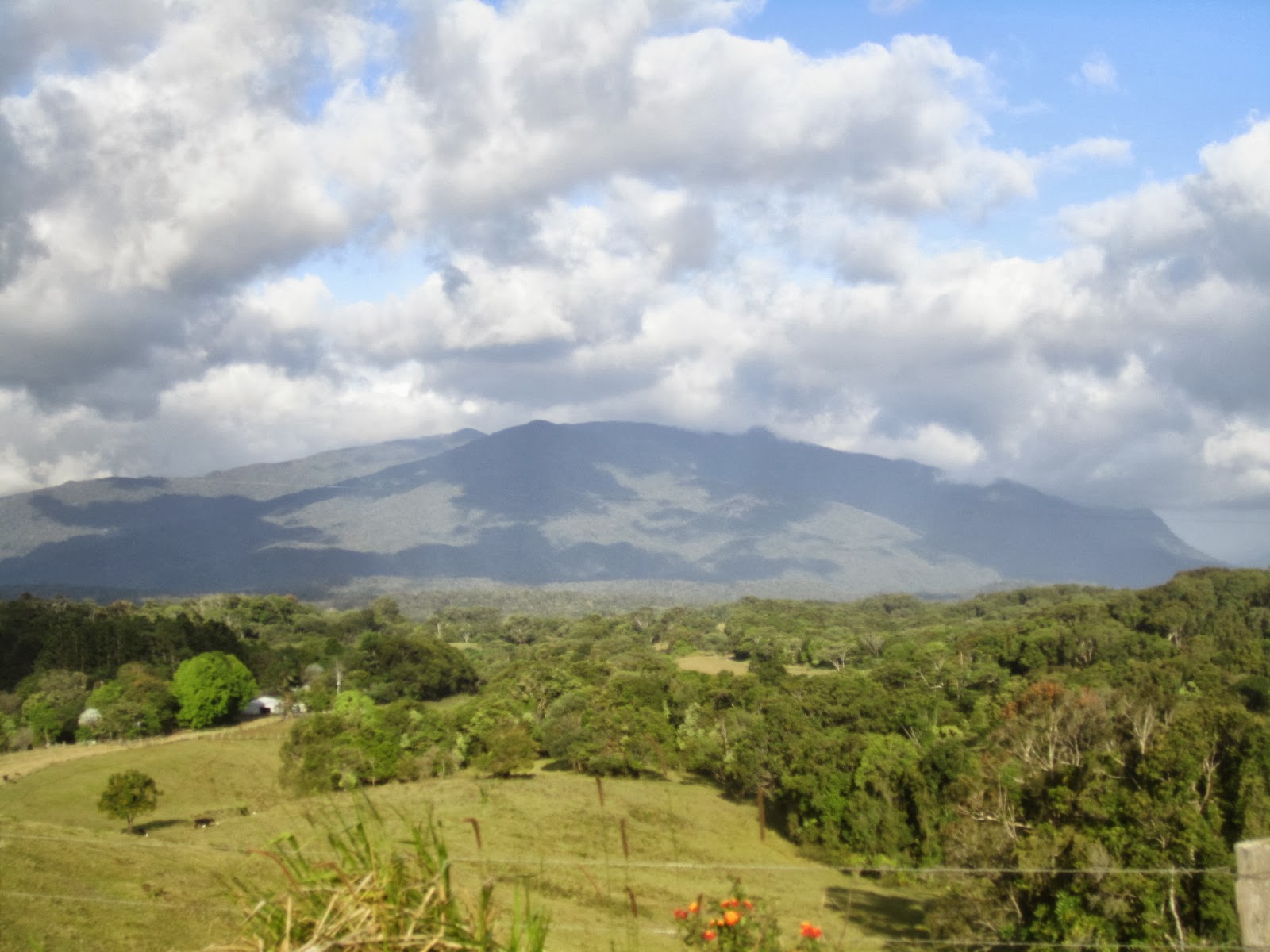
There was a good view over the town from the summit, with the Whitsunday Islands in the distance:


Then the next 15kms or so was a rollercoaster ride along a bumpy, rocky track, it was hard work but fantastic fun, especially as I've not had much previous experience of proper mountain biking.


There was another good view over the islands later:


...and a couple of fairly shallow creek crossings:


Then I suffered my first flat tyre  in ages. It turned out to be not a puncture, but a torn valve stem – probably caused by the roughness of the terrain. Obviously this couldn't be repaired so it was as well that I had a spare inner tube with me.


The last 10kms or so were fairly flat, but still good fun. I didn't see much in the way of wildlife, apart from this large goanna climbing up a tree:


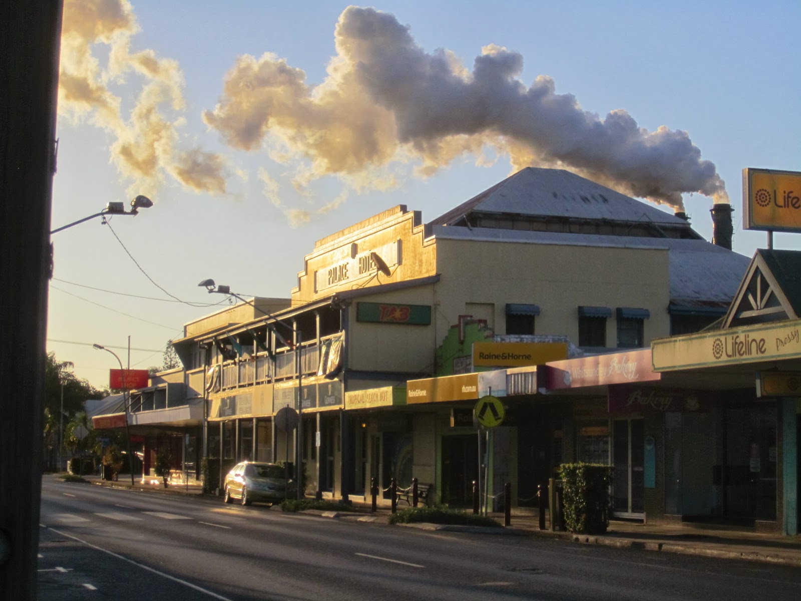
The route ends at Brandy Creek and from there it was about another 15km into Proserpine, the nearest town. I decided it would be good to take a look there as I'd not been there before, but needn't have made the effort, there is nothing much to see in Proserpine. Just one or two reasonably good Art Deco buildings:


...And a sugar mill belching out foul-smelling fumes over the town:


Distance cycled today just 56kms – but they were tough ones. I caught the bus back to Airlie Beach from Proserpine, feeling lazy after all the climbing earlier on.

Mt Stuart and Alligator Creek

Saturday 5th October 2013

The last Queensland ride from the Lonely Planet guide, this involved a 25km slog down the busy Bruce Highway, not a good road to be cycling, nor even driving, it has a very bad accident record and it's easy to see why, it's narrow, with lots of bends, little opportunity to overtake slow vehicles safely, and full of tired people who have driven long distances.


Anyway I made it safely to the turnoff for Alligator Creek which was about another 10kms along a quiet road. It's described in the Lonely Planet guide as a popular day use and camping area in the Bowling Green National Park, but when I arrived there was hardly anyone else there and the large car park and campsite were virtually empty.


Despite its name, Alligator Creek has no alligators, nor does it have any crocodiles. In fact I found it a bit disappointing, there wasn't much to see there. So I hit the highway again and detoured off east towards Mt Stuart, which involved a very arduous 10km climb, to a height of 584m:


Townsville and Castle Hill viewed from Mt Stuart summit. Magnetic Island is visible in the background.


 Looking back towards Mt Stuart.

I then enjoyed a fast 10km descent, followed by an easy 15km cruise back to Townsville.

Distance today 95kms.


Townsville and Magnetic Island

The Lonely Planet Cycling Australia guide has just 2 more rides in Queensland that I haven't yet done, and both of these are based in Townsville. I travelled there from Cairns by Greyhound bus with my bike; the Bruce Highway is not a safe road to cycle, and there isn't much of interest between the 2 cities. It's a 6 hour journey on the bus.


On arrival I found convenient accommodation at the Adventurers resort, and set off right away to climb Castle Hill, a 286m outcrop that overlooks the town centre. It's a pretty good workout:


I was impressed by how busy the track up to the summit was; the local population certainly looked a lot fitter than in most places in Australia.


On reaching the summit there are great views over the city and Magnetic Island, just 8kms offshore:


Friday 4th October 2013


Got the 0845 ferry over to Magnetic Island, it takes about 30 minutes to arrive at Nellie Bay. From there it's only about 8kms along the island's only proper tarmac road, to reach Horseshoe Bay , on the north side of the island. The road is steep, winding, and narrow in places, and there's a good cycle/walking path adjacent to it:


The route passes Geoffrey Bay which has a nice beach:


A bit further on I turned off to do a walk up to the WWII fortifications, and saw the old gun emplacements and also some koalas:


Arriving at Horseshoe Bay I had some great fish and chips, and sat on the beach for a while:


Retracing the route back to the south of the island I continued past Nellie Bay to Picnic Bay, then along a dirt road to West Point, from where you can see Palm Island, home to a large Aboriginal community:


Then it was back to Townsville on the ferry, and on arrival there was still time for a ride around the city before it got dark. There's a good city beach along the Strand, and also a lot of historic buildings. And Castle Hill certainly forms an impressive backdrop:


Distance today 55kms.


Wednesday, October 2, 2013

Yungaburra to Cairns

Tuesday 1st October 2013

Leaving Yungaburra heading east on the Gilliies Highway, the route continued to climb steadily for the first 15kms. On the way I stopped briefly at Lake Barrine, a beautiful spot, if somewhat touristy:


There's a scenic walk around the lake, one of the highlights is the twin Kauri Pine trees. these giants are over 45m tall and 6m in girth:


Back on the road, soon afterwards there was a view over Lake Tinnaroo in the distance:


Then there was a long winding descent back to sea level, for about 15kms I coasted along without having to touch the pedals. Even better, the gradient was gentle enough to maintain a reasonably safe speed, 30-40km/hr without having to apply the brakes. And there were views like this on the way down:


It was quite noticeable also how much warmer it became as I got closer back to sea level. After 45kms I reached Gordonvale where I stopped for lunch; from there it was a fast, flat ride up the busy Bruce Highway back to Cairns:


So that was the end of the ride, and another one in the Lonely Planet Guide completed. Quite a tough ride with all the hill climbing, but certainly very scenic and there were plenty of good eating and accommodation options along the route. I was certainly very lucky that the rain held off for 6 days, it seems that that is an uncommon occurrence in this very wet part of the world!

There are 2 more Lonely Planet rides starting in Townsville so I'm going to head down there in the next day or so. I won't be riding all the way there, 400kms along the Bruce Highway would not be much fun - so I'll be taking the bike on the Greyhound bus. I'll update the blog soon so please take another look in a few days.

Distance ridden today 71kms, trip total 384kms.

Mt Bartle Frere

Monday 30th September 2013

I'd been to the Visitor Centre when I arrived at Yungaburra yesterday to find out about walking routes up Mt Bartle Frere, Queensland's highest mountain, which I'd been told was quite close by. Normally Visitor Centres here in Australia are very good and have all the information anyone could want, but this one didn't have much about walking trails. Eventually I managed to get the staff member to find a map on the internet and print iit out for me, but it wasn't very detailed. I was told that it normally takes about 8-10 hours to do the return walk to the summit, so I thought that I should be able to manage it in a day.

I didn't manage to get a very early start, it was about 8am by the time I set off to cycle to the start of the walking track. It looked from the map that it was only about 15kms away so I thought I'd be there by 9am. In fact it turned out to be nearly 30kms away and about half that was along a dirt road, also I had to go up a lot of hills to get there. Result was that I didn't get to the start of the walking track until 1030am. On the way I took a photo from the Lamins Hill lookout:


It was somewhat overcast and it looked as though rain was coming. This is one of the wettest areas in Australia and weather conditions here can change very suddenly.

Anyway I locked my bike up at the start of the walking track and set off on the climb. There was nobody else around. After about 30 minutes I came to Bobbin Bobbin Falls, which I could tell from the map was the only source of water on the mountain, so I took the opportunity to fill up my water bottle:


Bartle Frere is entirely covered in dense rainforest, and the path to the summit is very uneven and overgrown. It's quite well marked with little orange reflective arrows on trees every 50m or so, but it's still quite easy to lose your way there, and apparently many people do.
In places there are large boulders you have to climb over:


...and there are tree stumps and other obstacles everywhere to trip over:


At about 1pm, after 2 and a half hours hard climbing, I reached the lower summit which is about 1470m above sea level. I decided to turn back at this stage, because I could see that it was another 2km and 200m ascent to the main summit, which would take at least another hour, and I knew that I had another 2 hour bike ride back to Yungaburra when I got back down to the car park. I was already pretty tired and didn't want to risk an injury from tripping or falling, as there was no mobile phone signal there and nobody around to help if I was unlucky enough to injure myself. It gets dark here around 6.30pm and I didn't want to be out riding after dark.

It took longer to come back down than it did to go up, I had to take it easy to avoid slipping on the path. I was back at the car park around 4pm and set off on the ride back straight away, pausing soon afterwards to take a final photo of the mountain that I had unsuccessfully tried to climb:


I was back at the hotel in Yungaburra around 6pm, pretty well exhausted. It was disappointing not making it to the top of Bartle Frere but at least I did have a good scenic walk through the rainforest, and even saw a few snakes. Maybe I will return and attempt the climb again one day, but would get there earlier and would avoid having to do a long bike ride as well on the same day.


Distance cycled today 60kms, trip total 313kms

Tuesday, October 1, 2013

Millaa Millaa to Yungaburra

Sunday 29th September 2013

The weather continued fine, and the terrain remained undulating, the elevation varying from 800-900m. Malanda, at 20kms, had Australia's oldest cinema but it was a fairly nondescript building so I didn't bother getting a picture. The town's hotel is reputed to be the largest wooden building in the southern hemisphere:


Nearby Malanda Falls are not very spectacular, but the pool area has been nicely paved for the local swimmers.


A bit further on is the Curtain Fig Tree which is pretty impressive:


I arrived at Yungaburra around 1.30pm and had lunch in the lovely old Lake Eacham Hotel. I decided to stay there as I want to climb Mt Bartle Frere, Queensland's highest mountain, tomorrow, it's an all-day trek
.

Took a short ride out to nearby Lake Tinaroo, a man-made lake formed by damming the Barron River, which is very popular with waterskiiers. There is a new Avenue of Honour there commemorating those who served in the Afganistan conflict:


Then I went for a walk along nearby Peterson Creek, an  where it's possible to view 2 rarely seen animals, the platypus and the tree-kangaroo. I did manage to spot a platypus briefly but wasn't quick enough to get a photo. No luck seeing any tree kangaroos, unfortunately.


Distance today 46kms, total 253kms

Herberton to Millaa Millaa

Saturday 28th September 2013

Another day full of ascents and descents. The Tablelands have a very high annual rainfall and this combined with their height above sea level means that visibility is often poor with mists and fog being very common. Fortunately the weather today continued very fine and sunny and I was able to enjoy the scenery at its best.

After about 10kms I took a detour through rainforest to reach Mt Hypipamee National Park, the main feature of which is the crater, a vertical sided vent blasted through granite millions of years ago by a gas explosion:


Also nearby are the Dinner Falls:


Another detour a little further on led to the highest point on Queensland's road system:


Approaching Millaa Millaa, the day's destination, there was a fantastic view from a lookout:


I arrived at Millaa Millaa in the early afternoon, so after checking in at the town's only hotel, I set off on a 18km circuit around 3 nearby waterfalls:


                                                               Elinjaa Falls
                                                 

Zillie Falls


                                                                  Millaa Millaa Falls


Distance today 72kms, total 207kms