Border Loop Ride
Anyway after 3 very enjoyable weeks in Sydney, for most of which the weather was dry and warm, I travelled by overnight Greyhound bus up to Surfers Paradise, arriving on Monday 5th November. With me I had my trusty Giant hybrid bike, which has already notched up 10000kms and still going strong, my skates, and a cycle-pannier full of essential items – a few clothes, bike tools, camera, and netbook. I like to travel as light as possible when cycle touring and I’ve always found one pannier to be quite adequate – I always stay in hotels/motels so don’t have to carry camping equipment.
I spent 3 days in Surfers and was very pleased that I had my
skates with me, it could almost be called Skaters Paradise because there are
many kms of lovely smooth flat bikepaths and pavements along the seafront.
$750 penalty just for skating in the wrong place? Are skates toy vehicles or just conveyances
(or both)?
After pretty much skating the whole Gold Coast over 3 days
it was time to get away from the city for some cycling through the mountainous
hinterlands. And as usual the Lonely Planet Cycling Australia Guide
provided a suitable route.
Day 1 – Robina to Murwillumbah
The weather had been warm and dry for the 3 days I spent in
Surfers Paradise, however on the night before I set off on the ride it rained
heavily. By the morning it had stopped raining but it remained very overcast
and it was obvious that more rain was on the way. I set off around 9am heading
south along the Gold Coast as far as Miami, then turned east arriving at the suburb of Robina around 1030.
Then it started to rain so I took shelter in a handy McDonalds for about an hour,
by which time the rain had stopped and it was brightening up nicely.
Heading out of Robina en route to the Springbrook National
Park the road is part of an Olympic
cycle training route, involving a 11km climb. This is the view looking back
towards the Gold Coast, and you can just
about make out the skyscrapers if you
zoom in a bit:
BTW – just a reminder – you can zoom in on any photo by
simply clicking on it.
The descent into the scenic Numinbah valley was steep and very fast:
Then another long, steep ascent led to the impressive
formation known as Natural Bridge, where a creek plunges into an underground
pool:
It’s reached via a short rainforest walk which was deserted
and wonderfully peaceful, despite, according to the LP guide, having hundreds of
thousands of visitors a year:
A bit further on, at the top of the climb there is a sign
marking the border crossing into New South Wales:
For some reason I forgot that I was now in a different time
zone – NSW has daylight saving and the clocks went forward 2 weeks ago – and
neglected to reset my watch. And it was to be another 2 days before I realised
this error.
From the border, another thrilling descent led into the
small town of Chillingham which had a charming old-fashioned general store and
not much else:
From here it was another 20 fairly flat kms to Murwillumbah, the day’s destination, lying on the banks of the Tweed River:
Arriving at what I thought was still 5.30 but was in fact
6.30 owing to the time zone change, I found accommodation at the strikingly
pink Imperial Hotel:
I’d travelled 98kms, not a great distance but it had
certainly involved a lot of climbing – so quite a tough start to the ride.
Day 2 – Murwillumbah to Nimbin
Yesterday’s rain had caused a bit of rust on the brake
cables and the brakes were sticking, so before
leaving all the components of the bike received a good lube.
Compared to yesterday’s ride this section was easy. The
route began with a gentle climb up the Tweed Valley, dominated by Mount
Warning, significant as it’s the first point of the Australian mainland to be
struck by the rising sun:
I reached Nimbin by lunchtime and was immediately accosted
by a fat cop. “Where have you cycled from mate?”
“Only from Murwillumbah”
“Blimey, all that way, how did you manage that? It’s very
hilly and dangerous”
“It’s only 52kms, that’s nothing – and there was hardly any
traffic”
“Well I reckon you’re crazy to ride that distance on these
roads. Stay safe anyway”
Pretty much a typical attitude out here in the country. You hardly ever see anyone cycling outside
the major cities.
Anyway Nimbin is a
wild and wacky place if ever there was one. It’s the epicentre of a region of
hippy communes, spiritual retreats, and New Age mumbo-jumbo, home to the Hemp
Embassy, a lobby centre for cannabis law reform, and it’s chock full of weird types most of
whom were stoned out of their brains.
I’d been there about an hour when it started raining very
heavily, so I was relieved that it had been such a short day’s ride. The rain
persisted through the evening . I decided
to forego the various exotic substances that were on offer everywhere, choosing
instead to relax with a pint or several on the balcony of the Nimbin Hotel:
Day 3 – Nimbin to Kyogle
It rained throughout the night and was still drizzling when
I awoke. I waited a while until the rain subsided and set off on a tough route,
with 3 steep climbs in the first 20kms. The scenery was fine, with views of the
Tweed Range in the distance, but it was too overcast to get any really good
photos.
It started raining after about the first 15kms and I spent an hour
sheltering at a small roadside café; then at 32kms just as I reached the town
of Kyogle it started to rain really hard. There was no point in going on as the
next available accommodation (and the intended destination for today) at
Grady’s Creek was another 36kms away –
so I checked into the Exchange Hotel
which was actually a lot nicer than it looks in this photo:
Despite being a very small town, Kyogle has a cinema so at
least there would be something to do that evening. I went along to check out
what was on, and found they were showing Looper, a film I’d been quite keen to
see, at 6.45pm. I bought a ticket – it was then 4.30pm according to my watch –
and went back to the hotel and read my book for a couple of hours. Returning to
the cinema 2 hours later, the lady who’d
sold me the ticket said the film had already started.
“Why? You said it started at 6.45pm, it’s only 6.40 now”
“No sir, it’s 7.40 – are you by any chance still on
Queensland time? We often get people forgetting to change their clocks when
they cross the border”
So I’d spent the last 2 days thinking that the time was an
hour earlier than it actually was!
There weren’t any more performances that evening so I went
for a nice meal nearby and returned to the hotel. It continued to
rain hard into the night.
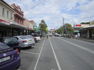
Kyogle main st has some nice Art Deco buildings -
The total distance today was just 32kms, though this had
included some tough climbs.
Day 4 – Kyogle to Beaudesert
I left early – around
7.30 am, as I had to make up the distance I had intended to cover
yesterday. Although the rain had finally stopped, it remained very overcast.
The route from Kyogle is known as the Lions Tourist Rd, having been funded by
various Lions Clubs, and was nice and smooth, flat and reasonably free of
traffic.
I made a quick refuelling stop at Wiangaree General Store :
The road passes through Grady’s Creek valley, said to be a
good place to spot platypuses, but the threatening rain was a big incentive to
keep moving, after stopping briefly to take some photos:
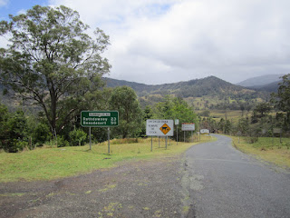
From Gradys Creek there was a steep 3km climb towards the
Queensland border:
Ascending further the weather started to brighten up and the
views got better and better:
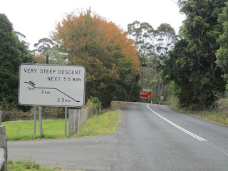
From the border the descent was very steep:
From here onwards it was flat all the way, and I had a
decent tailwind helping me along. The road became quite busy and there wasn’t
much of interest, apart from this car hanging from a tree branch:
I reached Beaudesert shortly after 1pm. Took a brief look around the museum, which
wasn’t very interesting, then found a
room at the Art Deco Beaudesert Hotel:
Total distance covered today was 102kms. Spent the rest of
the day enjoying the sunshine on the hotel balcony, and enjoyed a nice steak
dinner in the evening.
Day 5 – Beaudesert to Surfers Paradise
The start of today’s ride was delayed half an hour by the
first puncture of the journey, which happened on the way out of
Beaudesert. Weather was warm but still
overcast and not very conducive to taking photos.
The route back towards the coast involved a 500 metre climb
over Mt Tamborine. Winding up the ascent, through a canopy of rainforest, I met
a couple of other cyclists, the first I’d seen on this tour. Rode with them up
to the summit. At the top is the pretty
village on North Tamborine, which has several wineries. I restricted myself to
just visiting 2 of them as I wanted to keep a clear head for the steep descent
ahead.
The views from Mt Tamborine were fantastic:
At this point the bike started making some strange noises and on checking I
found that a spoke had broken in the rear wheel. Not entirely surprising, given
the amount of steep climbing I’d been doing, with a fairly heavy load. The wheel was still running reasonably true
so I knew it would see out the rest of the journey, as long as I took it fairly
easy.
The descent was via the one-way road known as the “goat
track” which runs past an army firing range:
Then it was another 30kms back to the coast, along a fairly
busy road. The last 10kms was through suburbs, with the coastal skyscrapers continually in
view:
I arrived back in Surfers Paradise around 4.30pm, having
covered 88kms today. Total for the 5 day trip was 372kms, which had included a
lot of climbing! Certainly an interesting route and good road surfaces, the
weather was a bit disappointing but it was nonetheless an enjoyable tour.
I’m planning on spending a couple more weeks here then may
head up to the Sunshine Coast for another ride detailed in the LP guide –
updates will be posted here in due course. Meanwhile the bike is having a rest
while I get the rear wheel repaired, so it’s back to the skates!


No comments:
Post a Comment