Monday 5th May
I found a bike shop quite close to where I'd been staying and bought thorn-resistant innertubes for both tyres, plus a new repair kit, and set off for Tempe, which lies across Tempe Lake from Phoenix:

Tempe, Mesa, and Apache Junction form a continuous conurbation stretching over 20 miles, and the cycle route followed a fairly quiet street lined with featureless suburban dwellings, many of which had saguaro cacti in their front gardens:


Leaving Apache Junction the route followed US 60 up a gentle gradient to Superior, where I decided to stop for the night:

Distance today 65.6 miles, total 508.9 miles
Tuesday 6th May
Got off to a good early start as the first 10 miles east of Superior involves a steady climb, and I wanted to get to the summit before the temperature warmed up too much. The route continued on US60 through Miami, where I saw this historic church:

Miami had a few old buildings, which were not very well preserved:

A bit further on, Globe also has a historic town centre:

Leaving Globe the route passes through the San Carlos Apache reservation, where, as is often the case in Indian reservations, there was a big casino:

Shortly afterwards I saw this memorial to Geronimo, a “rebellious medicine man” who led the Apache tribe on their last raids:

At Fort Thomas this memorial commemorates the fonder of Lions International, born nearby:

In a fast-food shop on the entry to Pima, I noticed this poster showing photos of numerous riders of the Southern Tier route over the last year, it seems that this place was a very popular place with cyclists. The owner took my photo to add to the wall, which was nice.

7 miles further I reached Thatcher; it was getting dark so I stopped there, staying at the Highway Inn.
Distance today 98.7 miles, total 607.6 miles.
Wednesday 7th May
Heading east from Thatcher the next town is Safford, which has a few historic buildings in the centre:


After Safford the services are very limited for the next 120 miles, until Silver City. There are no motels along the route, and camping facilities are very primitive, with no drinking water. I decided therefore to head for Clifton, some 9 miles off the route, where motel accommodation was available.
It was a 10 mile slog uphill to 4500' along US191, fortunately there was a tailwind most of the way:

Some of the desert plants were in bloom:


After 35 miles I reached Three Ways, nothing more than a crossroads with a single small store, and began a further 9 mile detour off the route, to reach Clifton, a former mining town now somewhat deserted:


Accommodation was at the Rode Inn Motel:

Distance today 44 miles, total so far 651.6 miles
Thursday 8th May
There was a long way to go to today's destination, and I knew from the map that there were 2 big hills to climb on the way, so I made an early start and was away soon after 7am. For the first 9 miles I was retracing my steps to Three Ways, mostly uphill.
Then from Three Ways there was a 13 mile climb up to an unnamed mountain pass, at an elevation of 6295 feet.

On the way up

At the top
From the top of the pass it was an enjoyable cruise downhill for about 6 miles until the New Mexico state border was reached, At this point it was necessary to advance my watch by 1 hour as I was in a new time zone.

There were very few services along today's route. The only place open was this bar at Buckhorn, where I stopped for a cold drink:

On the approach to Silver City there was another big climb, to 6230 feet:

Then a brief descent to Silver City, which lies at an altitude of just below 6000 feet.
It seemed a nice town, with a well preserved historic downtown district that had a definite feel of the Old West about it:


It seemed a popular place for cycling; I did see a number of lycra-clad riders in the town, which I hadn't seen anywhere previously on this tour.
Distance today 89 miles, total so far 740.6 miles
Friday 9th May
Another tough day lay ahead, as the route ascended to the highest point on the entire Southern Tier Route.
Leaving Silver City there was a gentle climb for about 20 miles, which led past the vast Santa Rita open cast copper mine:

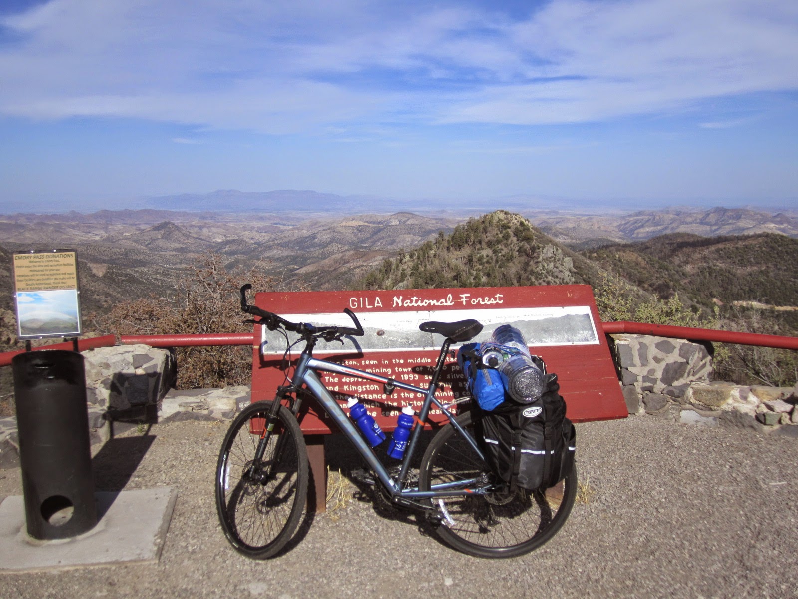
There followed 15 miles of much steeper climbing, to Emory Pass at an elevation of 8228 feet – certainly way higher than anywhere I'd cycled to before. The road was winding and fortunately lightly trafficked. It was a really hard, slow grind up there, involving some walking and pushing, but I made it eventually:

There was a nearby scenic lookout which had great views:
On the long, exhilarating descent I was relieved to have very efficient hydraulic disc brakes. There was a strong wind blowing in various directions, and I had to keep my speed down to avoid being blown over.
There was evidence of recent bushfire activity in many places:

After nearly 20 miles of cruising downhill, I reached Hillsboro, a charmimg old mining town, where I found a wine bar and got acquainted with some great New Mexico red wines.

Distance today 58.1 miles, total so far 798.7 miles
Saturday 10th May
I was expecting this to be an easy day, as the route profile looked to be flat or even slightly downhill, in marked contrast to the mountainous terrain I'd ridden the last 2 days.
The day got off to a bad start; I found that I had a flat rear tyre, despite having fitted thorn-resistant innertubes a few days ago; Hillsboro seemed to be full of large thorns and at least one had managed to get through. I mended the puncture but the air continued to leak slowly and I had to pump it up at least every 10 miles throughout the day. There were no bike shops until Las Cruces, the day's destination town, and I didn't have any more spare tubes.
But the biggest problem was a severe wind that seemed to be blowing in an unfavourable direction for most of the day, and which slowed me down a lot.
There wasn't much to see on the way. About 15 miles from Hillsboro I passed by Caballo reservoir, formed by a dam across the Rio Grande:

The route followed alongside the Rio Grande most of the rest of the day, and it was very dry at present:

It was a long hard struggle to get to Las Cruces and I made it around 8pm, just as it was getting dark.
Distance today 76.5 miles, total so far 875.2 miles
Sunday 11th May
After 12 days riding it was time for a day away from the bike. I rented a car and drove to Albuquerque, 210 miles north of Las Cruces, on Interstate 25.
There are a few interesting things to see there – the Art Deco buildings on Route 66 which goes through the centre of town, notably the “Pueblo Deco” Kimo Theatre and the Route 66 Diner:


Also the Old Town is a pleasant place to wander around:


I wanted to ride the world's longest cablecar up to Sandia Peak, 2.7 miles long, but when I got there it was not operating due to high winds. So instead I took a drive around a few of the locations in the TV series Breaking Bad:


Walter's house

The Carwash
Monday 12th May
Before leaving Las Cruces I found a bike shop and bought 2 new heavy duty thorn-resistant innertubes and had them filled up with special slime sealant which the proprietor assured me would guarantee no further punctures. We shall see.
The old town centre of Las Cruces does have a few nice adobe-style buildings, and a beautiful old cinema:


Just outside Las Cruces the route passed through Mesilla, which had a well preserved historic town centre. The old courthouse, now a gift shop, is where Billy the Kid was tried and sentenced.


A mile or so out of Mesilla I came across this group of cyclists who were riding the Southern Tier in the opposite direction. They had started from Florida 42 days ago. It was useful to swap details of our experiences so far on the route.

Then about half an hour later I met another cyclist coming from the opposite direction, his name is Dorian and he was on a year long cycle ride around the US trying to see as many different bird species as possible. He has a great blog here: bikingforbirds.blogspot.com
The route passed though the small town of San Miguel which had a distinctly Mexican character:


Approaching the Texas border but still inn New Mexico, I visited the La Vina winery and enjoyed a tasting of some very agreeable reds. Although only established in 2000, this is actually the oldest winery in New Mexico.

Crossing into Texas I met yet another Southern Tier rider, coming across the bridge over the Rio Grande. His bike certainly was impressively kitted out, I spent some time asking him what all the different gadgets were:

Then the route followed a well-surfaced bike path adjacent to the river for several miles:

The approach into El Paso was along a very busy main road, with no cycle lane:

El Paso is a large city with around 650000 inhabitants, and lies across the border from Ciudad Juarez which has 1.3 million. I took a brief detour over the border into Mexico, which involved crossing a bridge:

The border zone is heavily fortified and protected, Ciudad Juarez is reputed to be the most violent city in Mexico and is obviously a huge drug distribution centre. It's not a particularly pleasant place and I didn't stay long there. It was getting dark anyway but there wasn't much worth photographing:


At least I can now add another country to the list of places I've cycled in.
Returning to El Paso I enjoyed a very nice burrito and some good Texan beer in this atmospheric downtown joint, where nobody seemed to be able to understand English:

Distance ridden today 58.5 miles, total so far 933.7 miles
No comments:
Post a Comment