Across the US via the Southern Tier Route
Long ago, back in 1987, I bought a book entitled “Bicycling across America” which detailed a route across the middle of the US. Ever since then I've wanted to do this ride, and have now finally found the time for it.
More recently, I saw a newspaper article which contained a link to a number of long-distance cycle routes in the US , including 3 different routes crossing the country from west to east.
The route I've chosen to follow is the Adventure Cycling Organization's Southern Tier route which starts in San Diego, in the southwestern corner of the US, close to the Mexican border, and ends in St Augustine, northern Florida. It's the shortest of the transcontinental routes, at around 3062 miles, which was a big factor in its favour as I only have 2 months to complete the ride, and also, being entirely through the southern states, is likely to have the best weather conditions. By best I mean driest and hottest. I appreciate that not everyone likes riding in hot temperatures, but having done lots of long-distance riding in Australia, I don't mind the heat.
Rather than bringing a bike over to the US with me, I decided it would be easier to buy one in San Diego. I did bring a few cycle tools with me, and all the clothes I would need, but besides the bike I needed also to purchase a tent, and some basic camping equipment while in San Diego. Parts of the route go through remote areas where camping will be the only accommodation option. I'm intending to stay in motels as far as possible, but carrying a tent will at least give me the security of knowing I will always have somewhere to stay along the route.
How long will it take? As I mentioned earlier, I've allowed 2 months for the ride, which works out at around 50 miles per day, assuming no rest days. I intend to be back in the UK at the beginning of July, and have booked my return flight accordingly. However, I'm hoping to manage better than 50 miles per day where the terrain permits, so that I'll have more time left for possible rest days in interesting places along the route and even some side trips, and also to allow for slippage in the schedule in the event of encountering adverse weather, something I've experienced before when cycle touring.
I arrived in San Diego on the evening of Saturday 26th April 2014, after a very interesting 3 day stopover en route in Detroit, where I visited some great attractions including the Motown studios, the Henry Ford museum, the Detroit Historical Museum and the Institute of Arts, which certainly ranks amongst the world's great art museums.
Sunday 27th and Monday 28th April – getting ready to go
I set out looking for a new bike as soon as the shops opened, at 10am. By lunchtime I'd visited 3 bike shops, and found a Giant Roam, very similar to the bike I've been using in Australia. I rode my Roam to Cape York last year along 900kms of very rough dirt road and it performed well, and also I found the riding position comfortable, so purchasing another one seemed a safe choice.
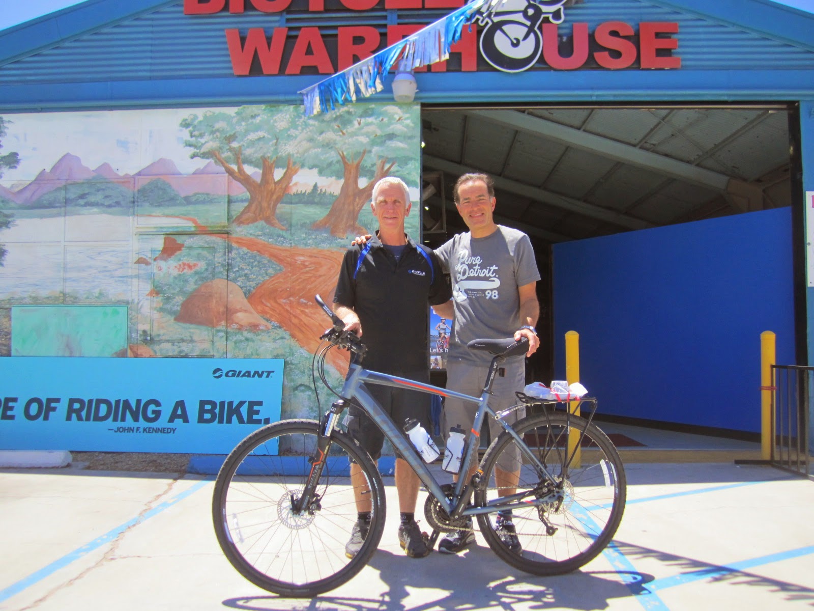
With salesman Jeff and the newly purchased Giant outside Bicycle Warehouse
I also had to buy a rack and some panniers, which necessitated visiting 2 more bike shops before suitable panniers were found. Then I had to visit several outdoor stores to find a suitable lightweight tent, sleeping bag and sleeping mat.
I'd hoped that the detailed map of the route I was to follow would be available in San Diego, but having phoned around quite a lot of bookstores, in the end I had to order it from Adventure Cycling who are based in Montana. They said it would arrive by express mail tomorrow and were as good as their word.
With all this shopping to do, there wasn't a lot of time to look around San Diego. I would have liked to see the museums in Balboa Park but they will have to wait for my next visit there. I did spend some time walking around the Old Town, rode the trolley car to the Mexican border, and cycled around the waterfront area.
Tuesday 29th April
The map arrived with the mail at 11am, and I was ready to set off. The route starts from Ocean Beach, and the ride there was along the harbour front:

On reaching Ocean Beach I had the obligatory start-of-ride photo taken with the Pacific in the background:

Nearby is Dog Beach, where the bike path starts:

It winds up into the mountains east of the city, passing along Interstate 8:

A brief section runs through Mission Trails Park:

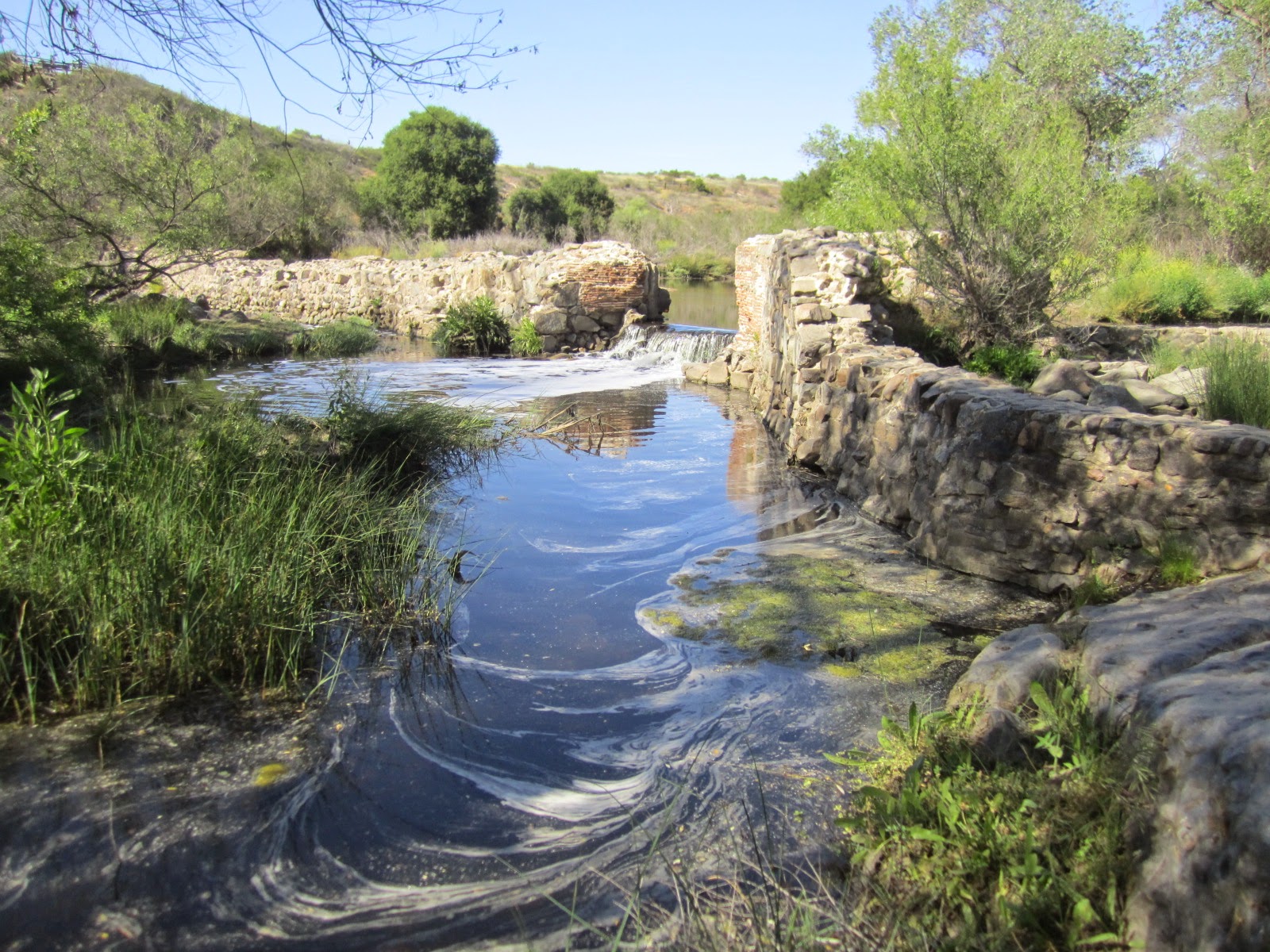
There are remains of an old dam on the San Diego River, an early attempt to bring a reliable water supply to the town:
It was then a steady climb through suburbs, until I reached Santee where I stayed in this comfortable motel:

Distance today 41.0 miles.
Wednesday 30th April
From the route profile, I knew that this was going to be a tough day, and it didn't disappoint.

And it was hot, around 33C.
Part of the route was on the Interstate 8 freeway, which had a good surface and a very wide shoulder:

The rest of the day was on Old Highway 80 which ran parallel to the interstate freeway:

The brown fence in this picture is the Mexican border:

After a tough climb to 4000' the reward was a 10 mile coast downhill to Ocotillo where I stayed in this motel:

Distance today 80.9 miles, total so far 121.9 miles
Thursday 1st May:
The temperature rose even hotter. I continued east along Highway 80, which had a very rough surface along this section:

I was certainly glad to have front suspension on my bike.
Looking back towards the mountain range I'd crossed yesterday, this sign warned of the strong winds I'd experienced yesterday:


I arrived in Brawley around 1pm and decided to stay the night there, since it was about 70 miles to the next town, Palo Verde. There are no services on the way between these two towns, and it was well over 35C – good enough reason to rest until tomorrow, and try and get an early start before it heats up too much.

Distance today 54.5 miles, total so far 176.4 miles
Friday 2nd May
Got off to an early start by 7.30am, heading east from Brawley on Route 78. The winds had died down and the terrain was fairly flat, yet the temperature continued in the high 90s. There were virtually no services along the route, so I carried 6 litre s of water with me.
After about 20 miles I passed through the Imperial Sand Dunes recreational area which had a scenic lookout:

This historical marker explains that this section of the road follows an old Indian trail from the Colorado River:

After a long hard slog in the heat I arrived at the next town, Blythe, around 4.30pm and checked into the Oasis Motel.


Blythe Main St
Distance today 89.2 miles, total so far 265.6 miles
Saturday 3rd May
Another early start. About 5 miles east of Blythe I crossed the Colorado River and entered Arizona:


Once in Arizona these distinctive sagauro cacti start to appear frequently by the roadside:


They can grow 50 feet tall and weigh 8 tons, taking around 150 years to do so.
The route then joined Interstate 10 for about 30 miles, then leaves on Route 60 heading through the small towns Brenda, Hope, and Salome, where I had a nice lunch after viewing the 9/11 memorial there:


Shortly after lunch I met two cycle tourists also following the Southern Tier route, but in a westerly direction, and we compared notes on the parts of the route we'd ridden.
I arrived at the small town of Aguila around 6pm and found a comfortable room in the town's only motel:

It had a good restaurant next door and I enjoyed a fine steak there.
Distance today 90.6 miles, total so far 356.2 miles
Sunday 4th May
The next town reached was Wickenburg, scene of a massacre of several stagecoach travellers by Apache Indiians:

The large saguaro cacti became more widespread:

Next town was Wittmann where there were a few historic buildings:

Then the route led through the sprawling suburbs of Phoenix. For about 15kms it followed a cycle path adjacent to the Arizona Canal, a flood mitigation scheme contained within a linear park:


It was along this section that I kept on getting punctures from small thorns that seemed to be everywhere. I lost count of the number, but by 8.30pm it was dark and I had run out of innertubes and also puncture repair patches. I had hoped to make it through Phoenix to Tempe, but ended up having to stay in the Imperial Suites in midtown Phoenix, which was actually very nice:

No comments:
Post a Comment